French Air Force Uses Cesium for Unreal for VR Helicopter Training
The French Air Force is augmenting training for helicopter pilots, crew members, and medics both in the air and on the ground with VR simulations using Cesium for Unreal.
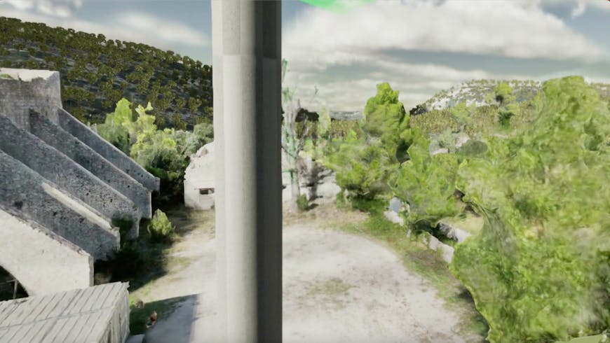
Student servicemembers train in first- and third-person with Cesium for Unreal. Courtesy French Air Force.
To minimize physical resources required for helicopter training and to properly prepare ahead of deployment, the French Air Force uses 3D geospatial data and collaboration in virtual reality. What do the terrain and buildings in a certain location look like? Should a pilot turn into the wind or away from it? How will the winch cables behave in different weather and at various altitudes? The French Air Force Heli Lab guides its trainees in answering those questions with accurate data at human scale, so they know what to do when they’re 40 meters above the ground.
The Heli Lab was created in 2019 with minimal funding, relying on free software and simulators with limited capabilities. Although this enabled the lab to imagine the possibilities for efficient training and begin work on its virtual reality program, the simulators could not communicate with troops on the ground, scenes had to be built from scratch, and locations were not precise, as they lacked a global map.
The lab began using Unreal Engine and Cesium for Unreal to build their own platform in 2021, and in 2022 the team formally introduced the demo. With three people working full-time on the demo, the French Air Force’s helicopter VR training went from technology readiness level (TRL) 1, an idea, to TRL 9, operations, in the span of a year.
View a trainee has in VR while being pulled up into a helicopter by a winch. Courtesy French Air Force.
The Heli Lab taps into the French Air Force’s drone imagery and videos of an area of interest, using Reality Capture to build that part of the world in 3D. The team adds these high-res insets to Cesium World Terrain and Photorealistic 3D Tiles, accessed via Cesium ion SaaS and streamed as 3D Tiles to Unreal Engine; the lab is now shifting to Cesium ion Self-Hosted, to securely host classified areas. 3D models of rotary wing aircraft enhance the trainings’ authenticity, ensuring crews learn on the helicopters that are available to them. Cesium for Unreal pairs 3D geospatial data with Unreal Engine’s high-fidelity rendering power, making their VR training program smooth and accurate.
With student servicemembers around the globe, learning with each other in simulation pods in France or via headsets in Gabon, having realistic training in a single accurate simulation is vital. The lab qualifies 18 pilots, 6-10 winch operators, and 6-10 medics each year. Current helicopter crew students are using the VR program as 30-50% of their training.
Initiatives like this one—starting from pockets of innovation from armed forces subject matter experts solving their challenges in a short loop by leveraging commercially available technologies—are beginning to take hold in service branches worldwide.
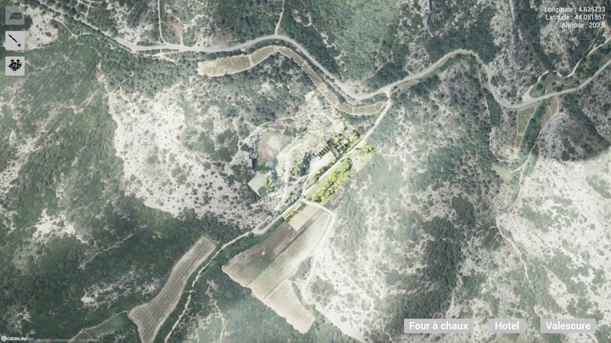
The French Air Force adds high-res insets to Cesium World Terrain and Photorealistic 3D Tiles. Courtesy French Air Force.
The Heli Lab’s VR training program will enable other teams to add and share their own datasets, broadening the reach of the platform and improving training and mission planning across the French Air Force with accurate 3D data for next-gen education and preparation.
Meet strict security requirements with Cesium ion Self-Hosted: hosting, tiling, and streaming for massive heterogeneous 3D data in your own environment. To build your own global-scale applications in VR using Cesium for Unreal, including for mission-critical situations, follow our VR Series for Geospatial Apps.