Windplanner Visualizes the Future of Renewable Energy with CesiumJS
As adoption of renewable energy expands, power providers, city councils, and individuals rely on Cesium-based Windplanner to see how wind turbines, solar panels, transmission lines, and large-scale energy storage will look in their neighborhoods.
With CesiumJS, Cesium Certified Developer Windplanner, headquartered in the Netherlands, enables its users to plan and show the visual outcome of energy project placement. In addition to a 2D map view of locations of proposed energy projects, Windplanner presents interactive 3D, with buildings, terrain height, trees, and existing and proposed wind turbines or other energy infrastructure. Users can see both the dots on a map and the results in highly precise 3D at the same time—2D and 3D layers can be modified, combining panoramas of the current setting and the future scenario. These clear pictures of changes to surroundings can allay residents’ and planners’ concerns over project size and location and can bolster support for local wind and solar projects.
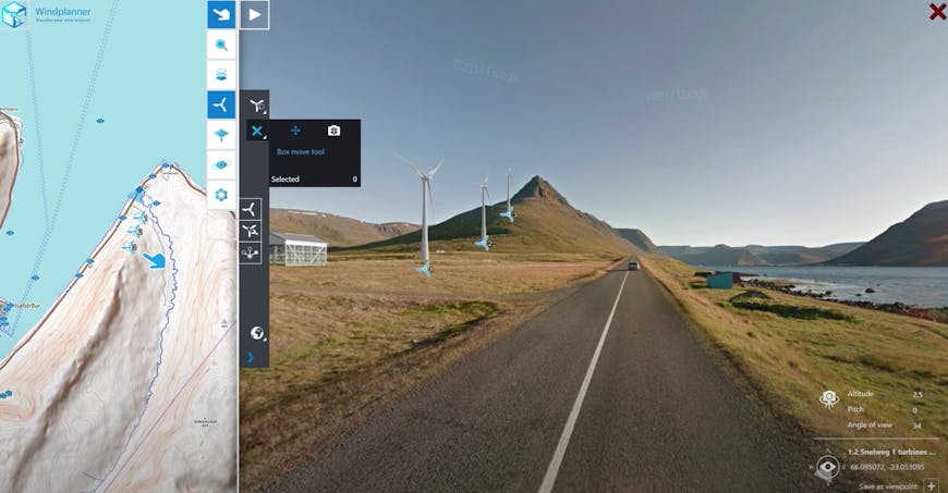
Windplanner uses panoramic photos on Cesium World Terrain to convey the scale and position of planned turbines. Courtesy Windplanner.
Panoramic photos come from Windplanner users’ own libraries or from a supplier such as Google Street View or Cyclomedia; they’re paired with Cesium World Terrain for detailed, up-to-date visualizations of the project areas. For wind projects, users choose a turbine from a predefined catalog or compile a turbine themselves, adjusting hub height, rotor diameter, wind direction, and color of the turbine. They can also set a specific date and time to adjust the position of the sun, allowing them to see the effects of shadows cast by the turbines or solar panels. Windplanner streams Cesium OSM Buildings and Bing Maps Aerial imagery from Cesium ion to CesiumJS to provide accurate geospatial context for the places that matter to decision-makers and citizens.
View energy projects from any angle, in 2D and 3D. Courtesy Windplanner.
Because users can share a selection of interactive viewpoints, planners, residents, and decision-makers can stream and collaborate on proposed layouts and locations. Users can even view the planned wind and solar power developments in VR for additional lifelike experiences and scale.
By providing real-world data for discussions and decisions, Cesium enables Windplanner to improve visualization and communication for energy projects all around the globe.
Want to bring precise interactive 3D to your apps? Sign up for a free Cesium ion account.