OpenSensorHub Connects Military Internet of Things with CesiumJS
Geospatially enabling sensors, things, and robots to interact across a common 4D space with geographic precision and accuracy, in a way humans can make sense of, is no small feat. OpenSensorHub makes it possible to connect these various systems and transform them into seamlessly integrated, spatiotemporally enabled, interoperable environments capable of addressing mission or business needs. The OSH team selected CesiumJS as its default viewer because of its time-dynamic object visualization over high-resolution 3D terrain data.
Primarily based on the Open Geospatial Consortium’s Sensor Web Enablement standards, OSH was released in 2014 as an open source, open-standards-based platform for bringing together nearly any sensor system as a location-enabled, geographically aware, web-accessible service. Since then, OSH has come to support a wider array of devices, including things (as in the Internet of Things) and robots. Botts Innovative Research, Inc, performs R&D services around OSH, and GeoRobotix provides the commercial SaaS offering.
The OSH team works with its community and customers to build “OSH drivers” to connect devices, integrating their data in a single collaborative visual environment with CesiumJS. OSH also provides training info for community members to develop their own OSH drivers.
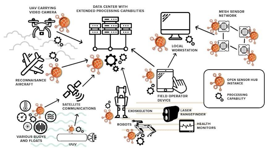
OpenSensorHub builds drivers to connect sensors, robots, and things and integrate their data. Courtesy OSH.
OSH works with sensors of all phenomenologies. Electro-optical, infrared, multispectral, hyperspectral, synthetic aperture radar, acoustic, lidar, radar, CBRNE, and radio frequency are just a few that OSH drivers convert to Sensor Model Language for common sensor discovery, geolocation, processing, visualization, and tasking. CesiumJS enables OSH customers to bring together this disparate sensor data and visualize it in one high-precision web-accessible 4D common operating picture.
Using CesiumJS, OSH’s customers can view and analyze their geospatial data on handheld devices or on a big screen in a command center. The OSH Web Client Toolkit also enables users to build visualization environments from multiple time-synchronized instances of CesiumJS, related time-synchronized charts, graphs, and sensor data visualizations, as well as synchronized 2D + time instances of OpenLayers, Leaflet, MapBox, and Esri mapping interfaces for decision-support solutions.
In this demo from I/ITSEC 2021 and GEOINT 2022, OSH uses CesiumJS in its OSH Web Client Toolkit to visualize the location, status, and disposition of sensors over time on a Maxar Precision3D 3D Surface Model of an urban training center in the 3D Tiles Next format. Users can see the sensor feeds from an unmanned aircraft system and a static camera, in addition to how they're arrayed in the real world across time.
OSH’s ability to integrate space-based, airborne, mobile, in situ, and terrestrial remote sensors of all types into a common 4D space has proven useful to customers from localities implementing smart cities to major airlines and the Department of Defense. Pairing OSH’s capabilities with CesiumJS has proven essential to command decisions in each of those environments, as CesiumJS is fed with real-time sensor data from OSH. OSH’s ability to also archive sensor data historically, and to replay synchronized data streams into CesiumJS, enables decision-makers to review past scenarios to better inform future decisions.
CesiumJS is free and open source. Download CesiumJS and bring a high-precision WGS84 globe to your app.