Umbra Manages Satellites with CesiumJS
Satellite imagery company Umbra uses synthetic aperture radar (SAR) to image Earth regardless of weather or time of day, with resolution ranging from 16 cm to 1 m. To manage mission planning and validate vehicle behavior for its fleet of satellites, Umbra uses CesiumJS.
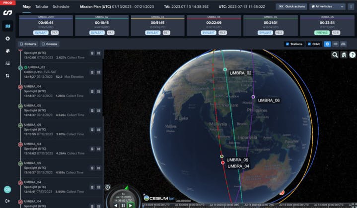
Omniscience, Umbra’s internal satellite visualization tool, is powered by CesiumJS. Courtesy Umbra.
Founded in 2015, Umbra images a variety of locations frequently to monitor change over time in support of climate research, disaster response, and defense, among other uses. SAR systems emit radio waves and then receive signals that bounce back, with different materials on Earth’s surface scattering or reflecting the signals. The signals from multiple points along a sensor’s path are combined and processed to provide a larger field of view and improve the image’s quality. SAR satellites can “see” through clouds or during the night to produce their grayscale images. Optical satellites utilize light and clear skies.
With six dorm-fridge-sized SAR satellites in low Earth orbit and two more slated to launch later this year, visualizing operations for a growing constellation is vital. The company began using CesiumJS for its internal visualization tool, Omniscience, prior to its first satellite launch in 2021—the company’s operations team uses Omniscience to know where satellites are and what their status is, displayed in 3D.
Umbra’s scheduling software generates a CZML with satellites’ location and orientation information as they are scheduled to collect imagery, enabling accurate and efficient captures. Telemetry from the satellites is also used to ensure the satellites are behaving as expected, to test and validate maneuvers. This data is hosted on Cesium ion, tiled into 3D Tiles, and streamed into Omniscience via CesiumJS, for reliable visualization on a high-precision WGS84 globe that can be shared across the company.
.jpg?auto=compress%2Cformat&w=870)
Philadelphia, PA, USA. SAR data © 2023 Umbra Lab, Inc. (Licensed under CC BY 4.0.)
“If you’re visualizing on a globe on the web, Cesium is your best option,” said Chris Brown, Umbra’s director of software development engineering.
Explore our CesiumJS tutorials to build your own aerospace app for internal use or broad sharing.