With Cesium, JMT Helps People See the Future Before It’s Built
"We're not putting a divided highway through your yard, I promise."
Dakota Mohan, Digital Delivery Lead at JMT, an infrastructure engineering firm, shared that comment while describing one of the biggest challenges in public engagement for transportation projects. Long before construction begins, project teams must communicate proposed changes to the communities they affect. Traditionally, those conversations rely on 2D engineering drawings, plan sheets, and poster boards. Yet for someone trying to understand how a roadway project might affect their property or community, a collection of lines on a page leaves a lot to the imagination.
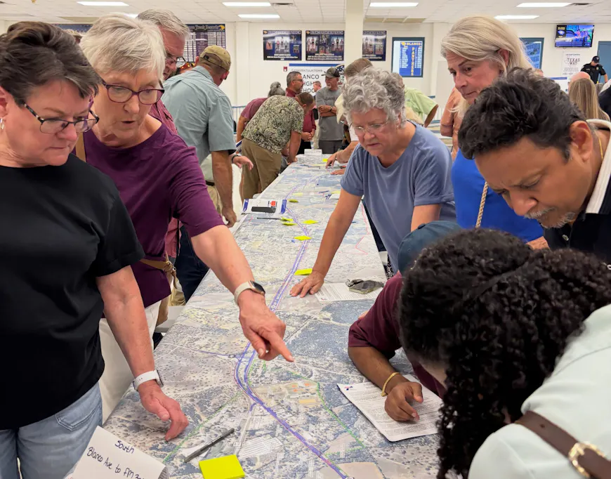
2D engineering drawings in a TxDOT public engagement meeting. Courtesy JMT.
As Mohan explained, most members of the public are not accustomed to reading plan sets or interpreting 2D representations of infrastructure. They're trying to answer much more practical questions: What is changing? What will stay the same? And how will it affect me?
Answering those questions was an important part of JMT's work on the Texas Department of Transportation's (TxDOT) US 281 Blanco County project, a roadway improvement effort spanning approximately 20 miles. To help stakeholders better understand the project, JMT used Cesium to place engineering designs within realistic, real-world context.
Bringing a Texas highway project to life
The TxDOT proposed expanding US 281 into a four-lane divided highway, creating a need to clearly communicate the impact of those changes to stakeholders and the surrounding community. JMT wanted stakeholders to see future conditions as clearly and realistically as possible.
Using engineering models managed through Bentley Infrastructure Cloud (BIC), JMT leveraged Cesium for Unreal to create a photorealistic representation of the future corridor. Working directly from the latest design information, the team could visualize proposed improvements alongside existing conditions within a realistic environment created using Google Photorealistic 3D Tiles.
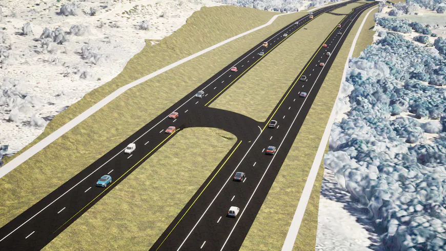
TxDOT US281 engineering data visualized in Unreal Engine using Cesium for Unreal. Courtesy JMT.
A key aspect of the resulting experience was the ability to compare existing conditions with proposed improvements. Rather than viewing the future roadway in isolation, stakeholders could see proposed changes alongside the roads, properties, and surrounding environment they already knew.
The resulting view provided a clear visual comparison between today's conditions and the proposed design, while also giving JMT a foundation for further enhancing the experience through custom materials, traffic simulations, and other visual improvements.
Realism in context
Mohan contrasted this workflow with earlier generations of 3D visualization, describing previous solutions as "very cartoony" and "very blocky." While those tools could communicate general concepts, they often lacked the realism needed to help stakeholders connect a design to their own surroundings.
To create realism stakeholders could relate to, JMT developed custom tooling to enhance materials and visual fidelity within Unreal Engine.
One anecdote from the US281 project captures the level of attention involved. During development, a project manager from JMT's Texas office looked at one of the visualizations and immediately noticed something was off. They pointed out, “that grass is way too green for Texas grass."
The texture was adjusted.
It's a small detail, but it captures the essence of the process. The goal wasn't simply to create a realistic visualization, but one that resonated with the people viewing it. Infrastructure projects are ultimately about real communities and familiar places. The more faithfully the experience reflected those places, the easier it became for stakeholders to connect what they were seeing on screen to their everyday life.
Existing conditions compared with proposed improvements along the US 281 corridor. Courtesy JMT.
From a project to a pattern
When JMT presented the final visualization, the public’s response spoke for itself.
Colleagues who attended the public involvement meeting said property owners were pulling out their phones to record the visualization. Mohan described attendees as being "in awe" of the level of realism and detail and noted how much easier it became for stakeholders to understand project impacts once they could see them in context.
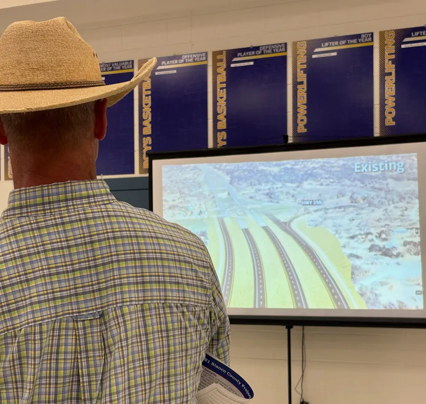
Attendee viewing the US 281 public engagement visualization during the TxDOT public meeting. Courtesy JMT.
The response extended beyond the meeting itself. The completed fly-through attracted nearly 15,000 views on the transportation agency's YouTube channel, a figure Mohan highlighted as particularly strong for a DOT project.
For JMT, the significance went beyond a single visualization. The Texas project was not an isolated success. According to Mohan, once transportation agencies saw the quality and realism possible with these workflows, many wanted similar experiences for their own projects. What began as a project-specific solution increasingly became a repeatable, sought-after pattern for clearly communicating design intent.
Building stakeholder-specific experiences
JMT is already expanding beyond the Unreal visualization workflow. Leveraging Cesium’s new design workflows and ion APIs, JMT is exploring experiences that provide easier access to engineering data, model properties, version comparison, and other interactive stakeholder engagement tools. These capabilities make it possible to build immersive stakeholder-specific experiences, including visualizing infrastructure projects in geospatial context, identifying changes between design versions, inspecting asset properties directly, and connecting to infrastructure project management systems for additional context.
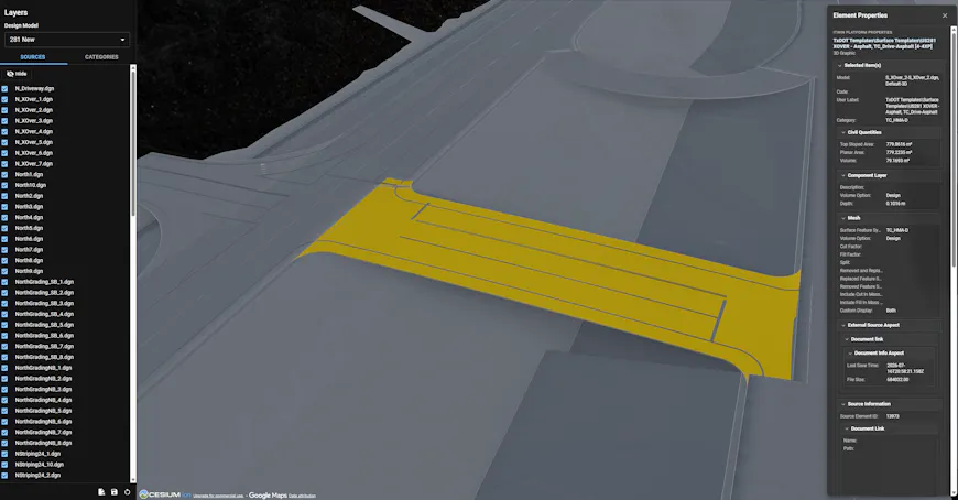
A new JMT app uses Cesium's design model workflows to show model changes and give engineers direct access to model metadata, as shown here for a roadway element. Courtesy JMT.
Just as public stakeholders have unique needs, other personas like engineers, project owners, and reviewers require distinct information from the model. Rather than limiting everyone to the same experience, JMT is exploring ways to create reusable applications that help each audience focus on the information and workflows most relevant to them. The common goal is giving people information in ways that are easier to consume, understand, and act upon, while maintaining a single source of truth in Bentley Infrastructure Cloud.
By using Bentley Infrastructure Cloud for engineering data management and Cesium to build custom stakeholder engagement applications, JMT is making engineering data more accessible and helping people see the future before it's built.
Interested in creating your own design review and stakeholder engagement experiences?
Learn more about the latest design workflows available in Cesium, including Bentley Infrastructure Cloud imports, engineering data access, version comparison capabilities, and more.