インフラデータを、学び、判断し、伝えるための体験空間へ
インフラ分野では、現実の施設や現場を3Dデータとして取得し、管理する取り組みが急速に広がっている。 CalTaのTRANCITY ARCADEは、Cesium ion、3D Tiles、Cesium for Unrealを基盤として、教育や訓練、安全理解、施設案内、コミュニケーションのための体験型アプリケーションを実現している。
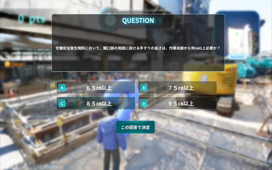
工事現場の3Dモデルをゲーミフィケーションコンテンツに使用 (提供:CalTa株式会社)
点群、写真測量、3Dモデル、Gaussian Splattingなどの技術により、鉄道、発電所、都市空間、公共施設といった複雑な環境を、これまで以上に高精度にデジタル空間へ再現できるようになってきた。
こうしたデータは、施設の構造を把握し、設備同士の関係を理解し、安全上の注意点を学ぶために活用されている。また、若手技術者に対して、普段は簡単に立ち入ることのできない施設の全体像を伝えたり、地域やステークホルダーにインフラの役割や価値を分かりやすく共有したりすることにも役立っている。
CalTaとキャドセンターが共同で開発するTRANCITY ARCADEは、、この問いに対する一つの答えである。インフラの3Dデータを、教育、訓練、安全理解、施設案内、コミュニケーションのためのインタラクティブなアプリケーションへ展開し、人々が学び、理解し、共有し、現場での判断に活かせる環境を実現している。
TRANCITY ARCADEは、写真、点群、3D Gaussian Splattingなどの現実世界のデータから生成された3D空間をもとに、移動ルート、クイズ、インタラクティブなオブジェクトなどを配置し、体験型コンテンツを構築できるプラットフォームである。
TRANCITY Nebulaで管理される現場データを、Cesium ionを通じて大規模3Dデータとして最適化・配信し、Cesium for Unrealによって地理空間の文脈を保ったままUnreal Engine上のリアルタイム体験へ接続する。
TRANCITY ARCADE:インフラデータを体験型アプリケーションへ
従来のTRANCITYやTRANCITY Nebulaは、インフラの3Dデータを取得し、管理し、共有するための基盤として重要な役割を果たしてきた。現場を記録し、点群や3Dモデルを管理し、関係者が同じ空間情報を参照できるようにすることは、インフラデータ活用の出発点である。
TRANCITY ARCADEの注目すべき点は、TRANCITY Nebulaで取得・管理・共有しているインフラデータを活用し、TRANCITY ARCADEと連携させることで、教育や体験のためのアプリケーションへ展開できる点にある。
ARCADEでは、現場から取得された3Dデータを、単に閲覧する対象として扱うのではなく、利用者が目的に応じて体験を設計できる空間として扱う。再現された施設や現場の中に、移動ルートを設定する。特定の設備や危険箇所にクイズを配置する。視点を切り替えながら施設全体を理解する。インタラクティブなオブジェクトを通じて、紙資料やスライドでは伝わりにくい現場のスケール感や注意点を学ぶ。
ここで重要なのは、「ゲーム化」そのものではない。インフラ現場における学習や教育は、単に知識を覚えることではなく、空間の関係性を理解し、状況を判断し、実際の行動に結びつけることが求められる。TRANCITY ARCADEは、現場データをそのような学びの場へ変えるためのアプリケーションである。
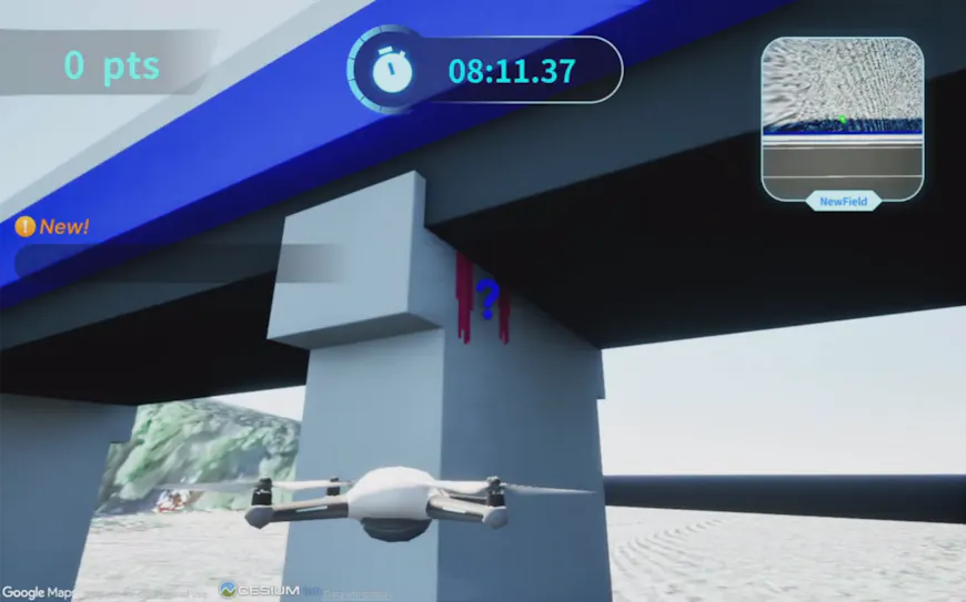
橋りょう点検をテーマにしたゲーミフィケーションコンテンツ (提供:CalTa株式会社)
J-POWERの現場で見えてきた、教育・安全・施設理解のユースケース
TRANCITY ARCADEの実用性を示す例として、J-POWERにおける取り組みがある。発電所のような大規模インフラ施設では、現場を理解すること自体が簡単ではない。設備は広範囲に分散し、構造は複雑で、すべての場所を自由に見学できるわけではない。安全教育においても、実際のリスクを現場で体験させることには限界がある。
J-POWERでは、発電所などのインフラ資産を対象に、CalTaと共同でCesium for Unrealを用いたゲーミフィケーションコンテンツの開発・検証を進めている。若手社員や新任者が、施設の全体像を早く理解する。。管理者が、設備や空間の関係性を直感的に説明する。こうした用途において、3D空間は、学習と判断を支える環境になる。
安全教育の観点でも、このような体験型アプローチには大きな可能性がある。容易に現場へ行くことができない場所や、安全上立ち入りが制限される環境であっても、インタラクティブなクイズなどを通じて、状況理解や学習を行うことができるからである。単に手順を覚えるのではなく、「なぜ危険なのか」「どこに注意を向けるべきなのか」を体験を通じて理解できることは、安全意識の向上にもつながる。
現実の現場で失敗することは許されなくても、体験空間の中では学ぶための試行錯誤ができる。普段は立ち入ることが難しいインフラ施設を、地域住民や一般のステークホルダーに分かりやすく伝える手段にもなり得る。インフラは社会に不可欠でありながら、その役割や仕組みが一般の人々には見えにくい領域である。
現実世界の施設を地理空間の文脈を保ったまま体験できることは、インフラの専門家だけでなく一般の人々にとっても、施設や周辺環境への理解を深めることにつながる。Cesiumは、その文脈を維持しながら現実世界のデータをインタラクティブなアプリケーションへ接続することで、こうした体験を支えている。
TRANCITY ARCADEは、産業向けの3D体験がどこへ向かうのかを示している。それは現実の施設、実際の業務、そこに関わる人々の学びや理解に寄り添うものである。より楽しく、より能動的に、より安全に学べる環境を作ることは、企業にとっても、そこで働く人々にとっても、地域社会にとっても意味がある。
J-POWER と CalTa が検証を進めているゲーミフィケーションコンテンツの画面イメージ(提供:J-POWER)
CalTaとキャドセンターがつなぐ、インフラ知見とリアルタイム3D実装
この取り組みを支えているのは、CalTaとキャドセンターそれぞれの異なる強みである。CalTaはインフラ現場のデータと業務理解を持ち、キャドセンターはリアルタイム3D表現とインタラクティブな体験設計を実装する力を持っている。TRANCITY ARCADEでは、この二つの専門性がCesiumの地理空間技術と結びつき、現場データを実際に使えるアプリケーションへと展開している。
やGoogle Photorealistic 3D Tilesのような技術検証、都市空間や施設空間の表現、インタラクティブな体験設計において、開発者としての実装力を持っている。
CalTaが持つインフラデータ活用の知見と、キャドセンターが持つリアルタイム3D実装力は、
- Cesium ion:3Dデータのホスティング、タイル化、ストリーミングを行うプラットフォーム
- 3D Tiles:大規模な3Dデータを効率的かつ最適化された形で配信・利用するためのフォーマット
- Cesium for Unreal:ゲームエンジン上で3D地理空間エコシステムを活用可能にするプラグイン
といったCesiumの技術と地理空間基盤の上で結びついている。 TRANCITY ARCADEのもう一つの特徴は、ノーコードアプローチにある。移動ルートやクイズ、インタラクティブなオブジェクトの配置を、専門的なゲーム開発の知識がなくても行うことができる。
こうして、現場データ、地理空間技術、業務理解、体験設計が統合され、教育や訓練に活用できる産業向けアプリケーションが実現している。
TRANCITYARCADEでのゲーミフィケーションコンテンツ作成状況 (提供:CalTa株式会社)
記録された現場から、学びと行動につながる空間へ
3Dデータの価値は、記録や管理の中だけで完結するものではない。人が理解し、学び、判断し、行動できる形になったとき、その価値はさらに広がる。
TRANCITY ARCADEは、インフラデータを「見る」ための3Dから、「使う」
ための3Dへ展開し、教育、安全理解、施設理解といった具体的な業務価値を実現している。Cesiumは、現実世界の3Dデータを地理空間の文脈を保ったまま実用的なアプリケーションへつなぐ基盤を提供している。詳しくは Cesium ionを参照されたい。
Across the infrastructure industry, organizations are increasingly capturing and managing real-world sites and facilities as 3D data. CalTa’s TRANCITY ARCADE uses Cesium ion, 3D Tiles, and Cesium for Unreal to create interactive applications for education, training, safety awareness, facility guidance, and communication.
A 3D model of a construction site used in gamified content. Courtesy CalTa Inc.
With point clouds, photogrammetry, 3D models, and Gaussian splatting, complex environments such as railways, power plants, urban spaces, and public facilities can be recreated in digital space with high fidelity. Teams use this data to understand the structure of a facility, grasp the relationship between different pieces of equipment, learn safety considerations, help younger engineers understand the full context of a site that is not easily accessible, or communicate the role and value of infrastructure to local communities and stakeholders.
TRANCITY ARCADE, jointly developed by CalTa and CAD CENTER, extends infrastructure 3D data so people can learn, understand, communicate, and make better decisions in the field. Cesium-powered TRANCITY ARCADE is a platform for creating experiential content by placing routes, quizzes, and interactive objects within 3D spaces generated from real-world data, such as photographs, point clouds, and 3D Gaussian splatting.
Site data managed in TRANCITY Nebula is optimized and streamed as large-scale 3D data through Cesium ion, then brought into a real-time Unreal Engine experience through Cesium for Unreal while preserving geospatial context.
TRANCITY ARCADE: Turning infrastructure data into experiential applications
TRANCITY and TRANCITY Nebula have played an important role as platforms for capturing, managing, and sharing infrastructure 3D data. Recording sites, managing point clouds and 3D models, and enabling stakeholders to refer to the same spatial information are foundational steps in making infrastructure data useful.
What makes TRANCITY ARCADE noteworthy is that infrastructure data captured, managed, and shared through TRANCITY Nebula can be used in connection with TRANCITY ARCADE and extended into applications for education and experiential learning.
In ARCADE, 3D data captured from the field is not merely something to view. Instead, it becomes a space where users can design experiences according to their purpose. Users set movement routes inside a recreated facility or site, place quizzes at specific equipment or risk points, switch viewpoints to understand the entire facility, and use interactive objects to learn scale, context, and safety considerations that are difficult to convey through paper documents or slides alone.
The goal is not gamification itself. In infrastructure training and education, learning is about more than memorizing information; it requires understanding spatial relationships, recognizing situations, and connecting that knowledge to real-world action. TRANCITY ARCADE turns site data into this kind of learning environment.
Gamified content themed around bridge inspection. Courtesy CalTa Inc.
Use cases for education, safety, and facility understanding at J-POWER
A good example comes from J-POWER. At large-scale infrastructure facilities, like power plants, understanding the site itself is not easy. Equipment is distributed across wide areas, structures are complex, and not every location can be freely accessed. In safety education, there are also limits to what risks can be experienced directly in the field.
J-POWER is working with CalTa to develop and evaluate gamified content using Cesium for Unreal for infrastructure assets, such as power plants. New employees and younger engineers can learn the full context of a facility more quickly. perspectives. Managers can explain relationships between equipment and spaces more intuitively. For these scenarios, 3D space becomes an environment that supports learning and judgment.
Experiencing real-world facilities while preserving their geospatial context can help both infrastructure professionals and the public better understand facilities and their surrounding environments. Cesium helps make these experiences possible by connecting real-world data to interactive applications while maintaining that context.
This type of experiential approach has significant potential for safety training. Even in places that are not easy to visit in person, or environments where access is restricted for safety reasons, users can build situational understanding and learn through interactive quizzes and related experiences. Rather than simply memorizing procedures, users can understand through experience why something is dangerous and where their attention should be directed. Even when failure is not acceptable in the real world, an experiential space allows people to learn through trial and error.
These experiences are not limited to internal training. They can also help communicate infrastructure facilities that are usually difficult to access to local communities and general stakeholders. Infrastructure is essential to society, but its role and mechanisms are often difficult for the public to see or understand.
TRANCITY ARCADE offers a practical example of how industrial 3D experiences can be applied today, as experiences connected to real facilities, real work, and the real people who learn from and engage with them. Creating environments that make learning more engaging, active, and safe has value for companies, for the people who work there, and for the communities around them.
Gamified content being developed and evaluated by J-POWER and CalTa. Courtesy J-POWER.
Connecting infrastructure expertise with real-time 3D implementation
TRANCITY ARCADE brings together complementary strengths: CalTa’s infrastructure data expertise and CAD CENTER’s real-time 3D implementation capabilities. In TRANCITY ARCADE, these two areas of expertise are connected through Cesium’s geospatial technology to turn site data into a useful application.
CalTa has worked on capturing, managing, and using site data in railway and infrastructure domains and provides a platform for handling infrastructure 3D data through TRANCITY Nebula. TRANCITY ARCADE is an extension of this work: it takes infrastructure data accumulated for management and visualization and extends it into applications for education and experience.
CAD CENTER has long worked on 3D city models, digital twin visualization, and real-time 3D expression. It has implementation expertise in technologies such as Cesium for Unreal and Google Photorealistic 3D Tiles, as well as in spatial visualization, facility environments, and interactive experience design.
CalTa’s knowledge of infrastructure data use and CAD CENTER’s real-time 3D implementation capabilities come together on a geospatial foundation built with Cesium:
- Cesium ion, the platform for hosting, tiling, and streaming 3D data;
- 3D Tiles, the format for efficient and optimized data; and
- Cesium for Unreal, the plugin for unlocking the 3D geospatial ecosystem for game engines.
Another key characteristic of TRANCITY ARCADE is its no-code approach. Routes, quizzes, and interactive objects can be configured without specialized game development expertise.
With CalTa, CAD CENTER, and Cesium coming together in TRANCITY ARCADE, site data, geospatial technology, domain understanding, and experience design are integrated, enabling an industrial application for education and training.
Gamified content being created in TRANCITY ARCADE. Courtesy CalTa Inc.
From recorded sites to spaces for learning and action
The value of 3D data expands when it reaches people in a form that supports understanding, learning, judgment, and action.
TRANCITY ARCADE extends infrastructure data from “3D for viewing” to “3D for using,” creating concrete operational value in education, safety awareness, and facility understanding. Cesium provides the foundation for connecting real-world 3D data to practical applications while preserving geospatial context.
Get started with your own Cesium ion account.