
Cesium at GEOINT 2026

May 3-6, 2026

Aurora, Colorado, USA

BOOTH 1303

Explore how Cesium powers training, planning, operations, and analysis across defense and intelligence.

Cesium. Join us at our GEOINT Reception. Tuesday, May 5, 2026, 9 pm - midnight. Mountain Pass Sports Bar, Upper Level, Gaylord Rockies Resort.

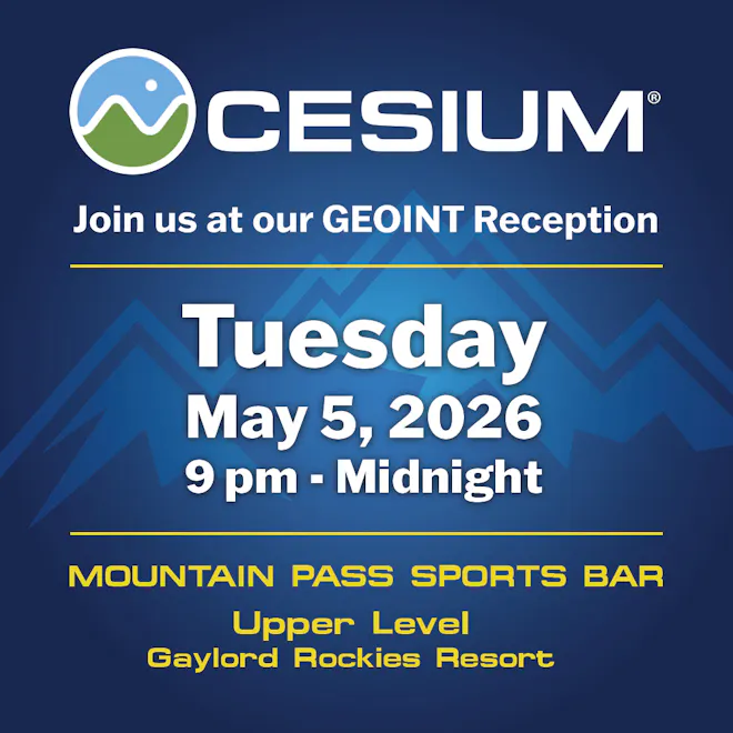
Enjoy drinks, sliders, sweets, and great company.

Where to find us

Experience Cesium in booth 1303

Self-Hosted Screenshot

Rapidly enable 3D geospatial applications in your own environment with Cesium ion.

Cesium ion Self-Hosted 

Cesium ion Self-Hosted provides hosting, tiling, and streaming for massive heterogeneous 3D geospatial datasets in your own environment, such as the Cloud, your data center, or edge devices.

Use Cesium ion Self-Hosted to support corporate policies or create air-gapped solutions that meet strict security requirements and can be deployed to remote, disconnected environments.

Learn more
Voxel visualization of geothermal temperature data surrounding Lake Thunersee, Switzerland. Visualized in Cesium for Unreal through glTF and 3D Tiles.

3D Tiles 2.0 

With broad adoption of 3D Tiles, including Google's Photorealistic 3D Tiles, this foundational standard is now evolving through an exciting community revision process for 3D Tiles 2.0, including Gaussian splats, time-dynamic 3D Tiles, vector tiles, and voxels.

Learn more

Can you land on the Moon?

Cesium Moon 

Try your hand at landing on the Moon using Cesium Moon and Cesium for Unreal—fun, immersive, and mission accurate. Stop by as many times as you’d like to compete for the top score on our Moon Lander Game.

Cesium Moon is complete 3D Tiles of the lunar surface that enables 3D visualizations, simulations, and analytics to support advanced digital twin creation. Cesium Moon combines multiple datasets available from NASA’s Lunar Reconnaissance Orbiter (LRO) into a single tileset with the highest resolution data located around the critical polar regions of the Moon. 

Learn more
One World Terrain Well Formed Format is an extension of 3D Tiles, including pPredicted accuracy in the NGA Generic Point-cloud Model (GPM) format.

One World Terrain Well Formed Format is an extension of 3D Tiles, including predicted accuracy in the NGA Generic Point-cloud Model (GPM) format.

OGC 3D Tiles and One World Terrain Well Formed Format

The One World Terrain Well Formed Format is an extension of 3D Tiles, enabling streaming of massive 3D datasets. We will be featuring sample data from One World Terrain, for which Cesium is proud to support the US Army and Vantor (formerly Maxar).

Learn more
A classified point cloud of Old City in Philadelphia, PA, USA, analyzed with Cesium ion

Reality modeling and analysis

We’ve incorporated iTwin Capture technology to bring reality modeling and analysis to Cesium ion. Reconstruct 3D reality models from photos, such as high-res drone imagery, as 3D Tiles mesh and seamlessly stream them. Combine your reality data with Cesium World Terrain or other curated 3D data for a unified view and improved situational awareness. Run AI-powered reality analysis on point clouds for segmentation and embedded metadata.  

Learn more
Cesium Developer Conference 2026. June 8-10. Philadelphia.

2026 Cesium Developer Conference

Join developers and integrators from around the world at the 2026 event in Philadelphia, where the community comes together to share ideas, solve real-world challenges, and shape the future of open geospatial technologies.

Learn more

Cesium Certified Developer program

The Cesium Certified Developer program recognizes your technical expertise in building on the Cesium platform. The certification program is free and open to anyone. Becoming a Cesium Certified Developer enables you to connect and collaborate with the greater 3D geospatial ecosystem.

Learn more
The Grand Canyon in Cesium World Terrain

Cesium Global 3D Content

Add real-world context to your applications using curated 3D data with global coverage. Cesium Global 3D Content and partner data is ready to use with any compatible client, including CesiumJS and Cesium for Unreal, Cesium for Unity, and Cesium for Omniverse.

Learn more
Cesium's GEOINT 2026 t-shirt design: white mountains and text on a green shirt. Cesium, the Platform for 3D Geospatial.

Open source for 3D geospatial

Cesium is deeply committed to openness and interoperability through open standards, open APIs, and open source offerings:

  • CesiumJS—open source JavaScript library for creating world-class 3D globes and maps with the best possible performance, precision, visual quality, and ease of use for the web.
  • Cesium for Unreal—combining the 3D geospatial capability of Cesium with the high-fidelity rendering power of Unreal Engine.
  • Cesium for Unity—combining the 3D geospatial capability of Cesium and 3D Tiles with the Unity ecosystem.
  • Cesium for Omniverse—enabling 3D geospatial capability for NVIDIA Omniverse, a real-time 3D graphics collaboration development platform, now supporting Isaac Sim.

Partner demos 

Each day at GEOINT 2026 brings a new partner showcases. See how organizations are using Cesium to power real-world applications.