XRF Connects and Integrates Missions with Cesium
In complex, high-pressure environments, how information is presented can be as important as the information itself. XReality Factory (XRF) uses CesiumJS and Cesium for Unity for a single shared operational view for better, faster decisions across real operations and training scenarios, throughout defense, security, and emergency management.
XRF's tools consolidate data sources and connect agencies via a single shared operational view with 3D geospatial context for better decisions. Courtesy XRF.
The volcanic eruptions on the Spanish island of La Palma in 2021 were the tipping point for XRF’s founding team, with expertise in extended reality and interactive technologies, to build tools to consolidate data sources and connect agencies via a single shared operational view with 3D geospatial context for better decisions.
“What we were developing in gaming is useful in emergencies, useful to our heroes,” said Raul Espada, XRF’s CRO.
XRF supports users in critical infrastructure, defense, emergency management, and security, working with the Spanish Armed Forces, Royal Netherlands Armed Forces, public authorities, and industry. In NATO exercises with armed forces from multiple nations on different systems, XRF tools served as the common operating picture (COP), enabling coordination across distributed teams, improving situational awareness, and accelerating decision-making with meaningful information, instead of a barrage of siloed data. The company is part of NATO’s EU Defence Innovation Scheme (EUDIS) and Defence Innovation Accelerator for the North Atlantic (DIANA) programs.
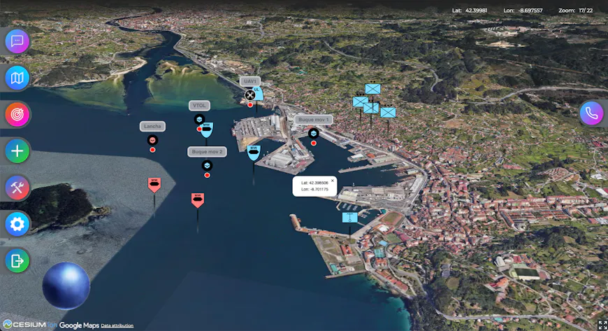
In NATO exercises, XRF tools served as the COP, enabling coordination across distributed teams. Courtesy XRF.
At the core of XRF’s dual-use command and control (C2) system is Compass, a platform for fusing data from several sources into a trusted 3D COP. With Cesium World Terrain or Cesium World Bathymetry via Cesium ion as Compass’s base, users add their own 3D models, drone imagery, and other information layers specific to their missions and organizational requirements for rapid, efficient delivery, streaming as 3D Tiles into CesiumJS for the web and Cesium for Unity for XR.
Around Compass, XRF developed complementary tools:
- Apolo, a mobile app for units deployed on the ground, built with CesiumJS;
- Colossus, a large multitouch command table for fixed control rooms, using CesiumJS;
- Sandbox, an XR multiuser command center for planning, training, and operations, built on Cesium for Unity and device agnostic across Microsoft HoloLens, Meta Quest, and Apple Vision Pro; and
- Hermes, XRF’s AI system that interprets scenarios to support decisions with natural language.
With real-world data available on a variety of devices, users can more quickly understand terrain, elevation, line of sight, and spatial relationships in context.
“Our goal has always been to integrate the solution the final user needs in their unifying system, so most of our effort goes into interoperability,” said Antonio Sanchez, XRF’s primary developer.
3D Tiles, an OGC community standard built on glTF and other 3D data types, enables XRF’s users to efficiently stream massive datasets, at any scale, together. The view their users need is the one that will load with the most detail, supporting immersive visualization and analysis on both high-end workstations and bandwidth-constrained devices.
XRF uses Cesium ion SaaS for testing, demos, and situations with reliable internet. The team and its users employ Cesium ion Self-Hosted for strict internal security requirements and off-grid environments.
“The level of performance—rendering continental-scale terrain down to tactical detail, with multiple users connected—is essential for user trust. In defense and emergency contexts, if the visualization stutters or lags, the system is not usable. The feedback we’ve received confirms that the 3D view is responsive and dependable,” Sanchez said.
XRF’s users report clearer briefings, faster alignment across teams, more confident decisions, and smoother transitions because of the connected, integrated approach, with the 3D geospatial foundation as a key enabler.
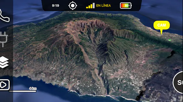
The volcanic eruptions on the Spanish island of La Palma in 2021 were the tipping point for XRF’s founding team. Pictured here is La Palma in XRF's Apolo, a mobile app for units deployed on the ground, built with CesiumJS. Courtesy XRF.
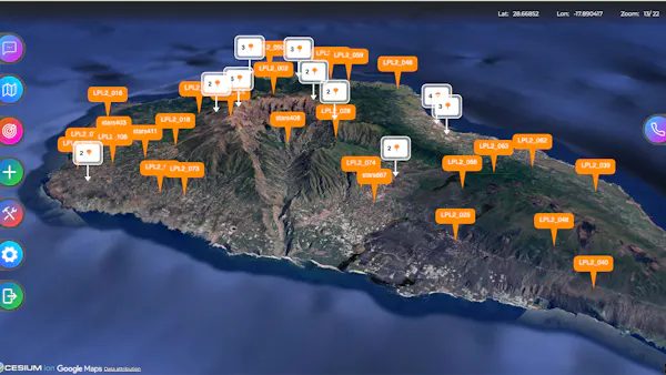
The volcanic eruptions on the Spanish island of La Palma in 2021 were the tipping point for XRF’s founding team. Pictured here is La Palma in XRF's Colossus, a large multitouch command table for fixed control rooms, using CesiumJS. Courtesy XRF.
XRF estimates that using Cesium reduced its time to first operational deployments by 30-40%. Because the team does not need to build or maintain the core 3D terrain or streaming architecture, they are able to focus on additional features—and lower their ongoing costs by replacing disconnected tools with one shared system, just as they’re doing for their users in defense, security, and emergency management.
Learn more about optimizing, hosting, and streaming your data in an immersive, shared source of truth for time-sensitive action.
Hear from XRF at the 2026 Cesium Developer Conference. Register to join us in Philadelphia in June.