Ocean Exploration Trust Uses Cesium for Realtime Underwater Modeling and Immersion Project
Nonprofit organization Ocean Exploration Trust (OET) seeks out discoveries on the seafloor, aiding research in geology, biology, and more while pushing the boundaries of technological innovation, education, and outreach. Working in the deep waters of the Pacific, the team uses Cesium for Unreal for its Realtime Underwater Modeling and Immersion (RUMI) project, fusing and sharing massive 3D and 2D datasets for discoverability, analysis, and education.
OET’s 2024 expeditions explore the Eastern, Central, and Western Pacific Ocean. This visualization scales from a global view into a dive track within the Hawaiian Islands. Courtesy Ocean Exploration Trust.
The launch point for Ocean Exploration Trust’s expeditions is Exploration Vessel (E/V) Nautilus, a 68-meter (224-foot) research ship. E/V Nautilus has space for interdisciplinary teams, labs, and remotely operated vehicles (ROVs). Capable of reaching depths of 4,000 meters (13,000+ feet) ROV Hercules is equipped with lights, high-resolution cameras, and sensors, and it can carry special instrument packages like the widefield camera array to capture high-res video and images for seafloor photogrammetry. In exploring previously unexplored deep-sea habitats worldwide, OET often must acquire data to create their own high-resolution maps. Because OET shares mapping and ROV operation data, expeditions contribute to US and international ocean and technology exploration strategies. This season’s ten expeditions are underway, live streaming daily, with real-time results available to the public.
RUMI combines disparate data streams in one interactive 3D space with Cesium for Unreal. Courtesy Ocean Exploration Trust.
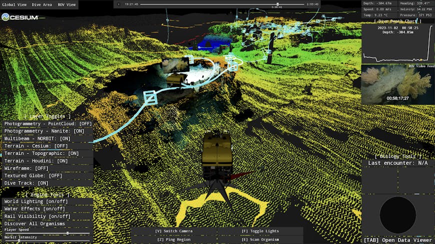
Funded by NOAA Ocean Exploration and the Office of Naval Research, the RUMI project is growing in its applications for both educational and scientific audiences. The project brings together the images and video from ROV Hercules, bathymetric point clouds from E/V Nautilus’s multibeam echosounder, and other dive observations in a georeferenced digital environment.
The team at Ocean Exploration Trust and its expedition partners gather vast amounts of data from previously unexplored areas, thousands of meters below the sea surface. “Combining these disparate data streams in one 3D space with Cesium is a unique alternative to downloading our data and using a spreadsheet,” said Jonathan Fiely, OET’s Media Production Specialist and the RUMI Co-Lead. “It’s a powerful way to discover our data in an interactive and engaging manner.”
In building digital models, RUMI uploads its data about the ocean to Cesium ion for hosting and tiling into 3D Tiles, the most efficient way to stream massive, detailed models and combine them for visualization and analysis. Cesium for Unreal’s built-in georeferencing system ensures these models are accurately placed on a WGS84 globe. The team accesses Cesium World Bathymetry for areas along coastlines and inland topographic coverage, to provide broader geospatial context. This ever-growing collection of seafloor data is streamed to Unreal Engine, with future plans to publicly release prototype experiences via pixel streaming.
RUMI uses Cesium World Bathymetry in combination with OET’s own bathymetric models. Courtesy Ocean Exploration Trust.
To learn more about OET’s work, tune in to Fiely’s talk at SIGGRAPH at 2 p.m. MDT on Sunday, July 28, 2024.
You can fuse and share your 3D datasets for research and education by signing up for a Cesium ion account.