A National Digital Twin Brings Infrastructure Education to Pupils across Scotland with CesiumJS
Across Scotland, high school pupils are learning about the infrastructure around them through a national digital twin built on CesiumJS. The National Digital Twin of Scotland brings together everything from buildings and power networks to live bus locations, weather, and environmental sensors, all in an intuitive 3D view that gives pupils a way to explore the systems they may one day help design and maintain.
The National Digital Twin of Scotland—a living, evolving digital representation of infrastructure, environment, and communities—brings real-world learning into the classroom through the GIBE Infrastructure Pathway, an ambitious education initiative connecting schools, universities, and industry through real-world challenges, emerging technologies, and Scotland's infrastructure. Courtesy Tech Unplugged.
The National Digital Twin is being created to complement a new Infrastructure Pathway in Scottish education, which incorporates the Global Infrastructure and Built Environment (GIBE) course. Created by a group of educators, academics, and industry professionals, GIBE has been approved by Scotland’s qualification authority, with over 50 schools and 600 pupils expected to join for the Academic Year 2027–28.
Primary pupils in the GIBE course learn about wind power by adjusting windspeeds on a fictitious island, Eilean Mór, and measuring the effect on wind turbines; they read graphs to analyze real-time CO2 measurements from around the country.
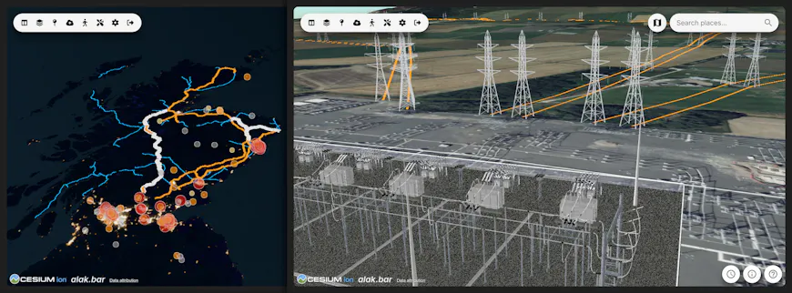
Pupils can view actual transmission lines and sample a substation from Bentley Systems to learn how energy is distributed across a region. Courtesy Alakbar Zeynalzade.
Secondary school pupils take on even more involved projects. In one unit, they were assigned to design a house that could fit in a courtyard. The pupils visited the real courtyard, took 360-degree images of the location, visualized it in CesiumJS, and measured the space in the digital twin using Cesium’s measurement tools. The pupils then designed a house and brought the CAD design into their view of the National Digital Twin to check their work and see how it looked on site among the other existing buildings from the Twin’s own drone-scanned photogrammetry, supplemented by Google’s Photorealistic 3D Tiles. They could even switch on the thermal drone photogrammetry to understand the thermal nature of their site. Finally, they also got to 3D print their houses. With projects like these, pupils engage in a recognizable version of an actual design workflow. Not only are they learning how infrastructure professionals operate, but they’re working with the digital tools actually used in industry.
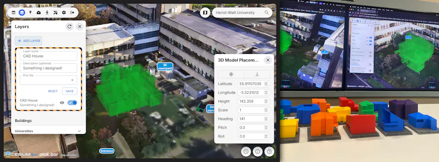
Pupils designed houses for a specific space and positioned their design within the National Digital Twin of Scotland in CesiumJS. Then they 3D printed their models. Courtesy Alakbar Zeynalzade.
All of these educational experiences reference the Twin built in CesiumJS. In addition to exploring the natural and built environment with global terrain and satellite imagery, pupils can explore numerous real datasets showing the country’s infrastructure: photogrammetry created with iTwin Capture Modeler, BIM and CAD content, real-time sensors from across the country, and infrastructure datasets come together in CesiumJS. More than a 3D map, the Twin gives location and context to infrastructure data from across Scotland, bringing static assets, design models, sensor readings, live feeds, and simulations into a common environment.
“The National Digital Twin of Scotland is giving life and location to publicly available data. The impact of this program goes well beyond introducing pupils to new technology. It gives them opportunities to investigate real infrastructure, work through authentic design challenges, and see how the concepts they learn in the classroom are applied in industry. Perhaps most exciting of all is seeing pupils at primary and secondary school becoming familiar with complex live data streams and making systems level decisions from their own analysis. These young people are definitely getting ready for a brave new world—CesiumJS is the platform that has made all this accessible across the country.”
- David Robertson, Director of University Partnerships, Bentley Education
One of the priorities for the digital twin was that it be lightweight. Scottish pupils have access to Chromebooks and iPads through school, so the application needed to be able to run on their devices. Building on CesiumJS meant the digital twin could provide sophisticated 3D geospatial experiences while running in a browser. With easy-to-manage settings that allow pupils to select how much data is streamed and at what detail, the Twin can even run on pupils’ phones. That accessibility is what makes national adoption of the Twin possible.
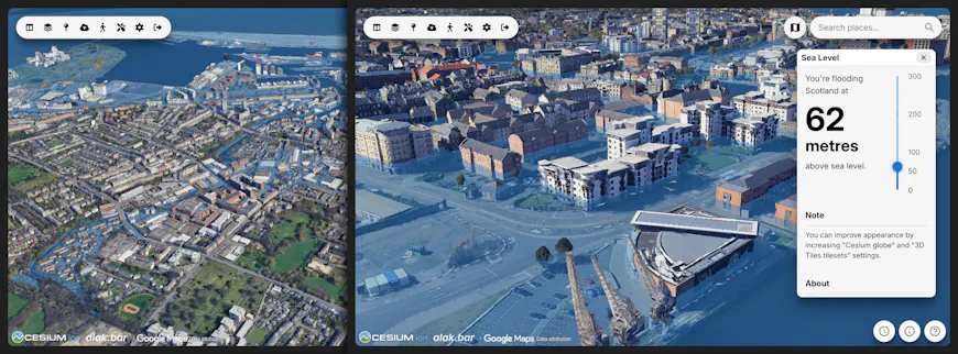
With its flood simulator, the National Digital Twin of Scotland allows pupils to simulate sea level rise. When the water level simulation is combined with Google Photorealistic 3D Tiles, students are able to see the water level compared to each floor of a building. Courtesy National Digital Twin of Scotland. Courtesy Alakbar Zeynalzade.
“The Infrastructure Pathway for secondary schools is a new curriculum that uses The National Digital Twin of Scotland to complement learning. Pupils learn about modeling, operations management, and simulation using the tools that are actually used in research and industry. The curriculum has already been accepted as entry requirements for eight of Scotland’s twelve universities, and a growing number of secondary and primary schools across the country are adopting the curriculum. A key role of the Digital Twin is to foster curiosity-driven learning by enabling pupils, whether in urban or rural communities, to explore and investigate the infrastructure that exists in their local environment.”
- Dr. Daniel Mitchell, Research Associate, University of Glasgow
The National Digital Twin of Scotland and GIBE course were created in a unique collaboration between Heriot-Watt University, the University of Edinburgh and Midlothian Schools, in association with the University of Glasgow. The team consulted closely with industry partners to understand the skills employers need and translate real-world infrastructure challenges into practical classroom projects. Throughout, Bentley Education has supported and advised the team.
Live weather data and forecasts visualize wind speeds while animated wind turbines, representing the country’s actual wind power system, spin at the appropriate speed. Courtesy Alakbar Zeynalzade.
While educators, universities, Bentley Education, and industry partners all helped shape the initiative, Alakbar Zeynalzade has led the software development of the National Digital Twin, with contributions from university interns. He came to the project with limited GIS experience and no previous experience with Cesium but found support needed to build such an ambitious project.
“3D on the web and GIS can be very complex, not to mention getting it all to run on Chromebooks and iPads! I've been able to get this far, largely as the sole developer, because of the quality of Cesium's documentation, Sandcastle examples, and forum discussions (plus help I got when I was at the Cesium Developer Conference!).”
- Alakbar Zeynalzade, Lead Software Engineer, Heriot-Watt University
To bring infrastructure data into your own CesiumJS application, check out our guide to Cesium and BIM/CAD data. To help give pupils in your area access to industry tools for GIS and infrastructure, reach out to Bentley Education.