Blyncsy Shows Transportation Agencies the Future of Roadway Maintenance with CesiumJS
Keeping roads well maintained and safe for travel requires up-to-date information about roadway conditions, including potholes, missing signage, guardrail damage, and other potential safety hazards.
Blyncsy, founded in 2014 and acquired by Bentley in 2023, uses AI, machine vision, and cloud computing to help US state and local transportation agencies spot issues more efficiently than with resource-heavy manual methods. CesiumJS plays a critical role in helping Blyncsy show potential users how the company’s data can be used in a visualization engine.
Striping retroreflectivity across the US. Courtesy Blyncsy.
Blyncsy gets road pictures by crowdsourcing images from over 1,200,000 vehicles, including privately owned commercial and fleet vehicles and delivery trucks. The company anonymizes the data and securely stores it in the cloud, where it can be studied and analyzed by machine learning systems, machine vision, and AI. The analyzed data is then delivered to users through Open Geospatial Consortium (OGC) APIs, ensuring seamless integration with a variety of platforms, including Cesium and other transportation management systems, for georeferencing, visualization, and analysis.
“Selling data is abstract. Since the beginning, long before we were acquired, CesiumJS has provided a flexible, easy to use, and high-performing way to show the value of our solution to potential customers,” Pat Brown, principal software engineer at Blyncsy, explained. “Cesium’s open-source approach was also a big draw for us—it gave us the freedom to innovate without being constrained by licensing fees or proprietary limitations.”
Brown and his colleagues use CesiumJS not only to attract new business but also to save valuable engineering resources: “With CesiumJS we can focus our team’s time on building our platform instead of the front-end engineering that would be needed to eloquently visualize the data.”
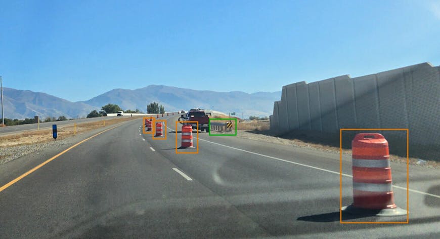
US interstate highway system roadway safety and maintenance conditions. Courtesy Blyncsy.
In 2023, Blyncsy began publishing a series of their AI-powered detection maps to provide state and local agencies with free access to select datasets. Built on CesiumJS with TerriaMap, that series includes a comprehensive public map of all interstate highways in the continental US, showing key roadway assets such as guardrails, speed limit signs, and work zones to support roadway safety and maintenance conditions.
Laura Chace, president and CEO of Intelligent Transportation Society of America (ITS America), lauded the release of Blyncsy’s publicly available maps. ITS America was established by Congress in 1991 to serve as an advisor to the US Department of Transportation and advocates for a smarter, greener future transformed by transportation technology and innovation.
“The application of advanced technologies like AI, combined with new sources of data, are transforming the transportation sector, giving us better information as we make investments in safety and mobility,” Chace said in a Bentley blog. “We applaud companies like Blyncsy for deploying these forward-thinking technologies and making this digital infrastructure data available to the public in an accessible format.”
Blyncsy uses AI, machine vision, and cloud computing to help US state and local transportation agencies spot roadway issues. Courtesy Blyncsy.
Learn to easily and eloquently visualize and analyze data from multiple sources with CesiumJS.
Join us at the 2025 Cesium Developer Conference to connect with Blyncsy and others with technically oriented, community-driven tracks.