Cesium Releases in February 2025
In January, we shared our code review guide, which we recently created and made available in our new public community repo, celebrated Danny’s Patriot Award from Pennsylvania Employer Support of the Guard and Reserve, and began calling for presentations for the 2025 Cesium Developer Conference. We look forward to seeing you in Philadelphia in June!

We made improvements across Cesium this month. To get notifications about our monthly releases, you can subscribe to the Cesium release roundup thread on our community forum.
CesiumJS 1.126 Release
CesiumJS 1.126 is now available. Highlights of the release include:
- Add
ITwinData.loadGeospatialFeatures(iTwinId, collectionId)function to load data from the Geospatial Features API. #12449 - Fixed error when resetting
Cesium3DTileset.modelMatrixto its initial value. #12409 - Fixed the parameter types of the
ClippingPolygon.equalsfunction and fixed cases where parameters toequalsfunctions had erroneously not been marked as 'optional'. #12394 - Fixed Draco decoding for vertex colors that are normalized
UNSIGNED_BYTEorUNSIGNED_SHORT. #12417
For more details, see the changelog.
Cesium for Unreal 2.13.1 Release
Cesium for Unreal v2.13.1 is now available. Highlights of this release include:
- Added
CesiumUrlTemplateRasterOverlay, allowing a raster overlay to be added using tiles requested based on a specified URL template. - Added
EstimateTimeZoneForLongitudemethod toACesiumSunSkyto set a reasonableTimeZonevalue at the given longitude. - The "Place Georeference Origin Here" button on
ACesiumGeoreferencewill now adjust the time zone of theACesiumSunSkyinstances that reference it, based on the new origin's longitude. This improves user experience when moving the origin to locations where it would be nighttime in the current time zone. A newEstimateTimeZoneForLongitudemethod onACesiumSunSkycan also be invoked manually from C++ or Blueprint. - Added
RequestHeadersproperty toCesium3DTileset, and the various Raster Overlay classes, allowing custom headers to be specified. - Worked around a limitation in Unreal's
FMatrix -> FTransformconversion that prevented models with a small scale factor (e.g., where vertex positions are expressed in millimeters) from rendering because their scale was treated as 0.0.
Check the Cesium for Unreal release and the Cesium for Unreal Samples release for the full list of updates.
Cesium for Unity 1.15.1 Release
Cesium for Unity v1.15.1 is now available. Highlights of this release include:
- Exceptions in either C# or C++ code are now handled much more reliably.
Check the Cesium for Unity changelog for the full list of updates, and follow our Cesium for Unity tutorials to get started.
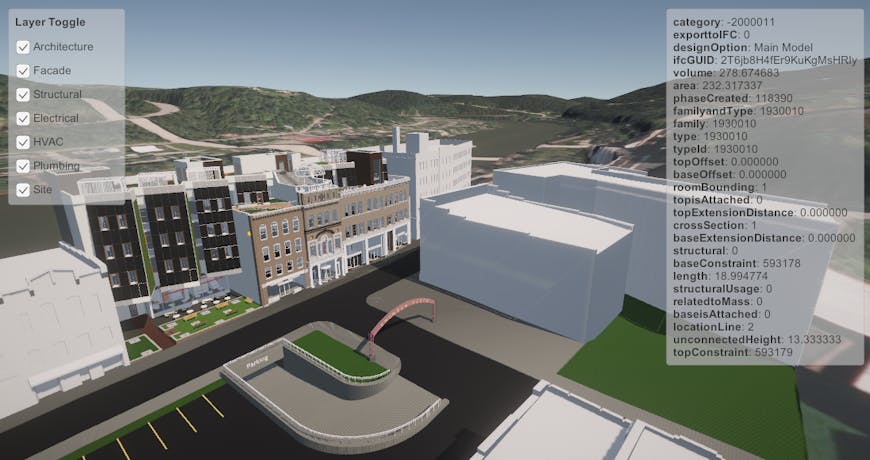
Snowdon Sample Model from Autodesk Revit, streamed with 3D Tiles and visualized using Cesium for Unity. Featured in Level 08_CesiumArchitecturalDesign in Cesium for Unity Samples.
Cesium ion Updates
Cesium ion SaaS
- Cesium OSM Buildings and Cesium OSM Buildings for Cesium World Bathymetry datasets have been updated based on the OSM Timestamp of Jan 13 00:00 GMT 2025.
- In addition to the Bing geocoder, Cesium ion now provides the Google geocoder for use in your applications. See this sandcastle for implementation.
Cesium ion Self-Hosted
- In addition to the Bing geocoder, the Google geocoder is now available to applications using Cesium ion Self-Hosted when your Self-Hosted installation is connected to your Cesium ion SaaS account. See this sandcastle for implementation.
- Cesium ion Self-Hosted v1.6.0, including the ability to upload data from Azure for tiling, will be released no later than early March 2025.
Check the changelogs for the full list of updates for Cesium ion SaaS and Cesium ion Self-Hosted.
Powered by Cesium
DroneDeploy enables stakeholders to examine the entire life cycle of a project with its drone software and viewer, which use 3D Tiles and Cesium ion Self-Hosted to make massive photogrammetry datasets manageable and accessible. With Cesium’s 3D Tiling Pipeline, DroneDeploy puts its engineering resources into its custom viewer rather than model processing, and users get photorealistic 3D models for decisions based on reality.
Capture high-resolution aerial data to align teams and keep AEC projects on track. Courtesy DroneDeploy.