Cesium: Series A Investment, Spinning Out, and the Future of 3D Geospatial
We’re thrilled to announce that we’ve closed on a $5 million Series A investment from Falcon Global Capital. We’ve also spun out from our parent company, Analytical Graphics Inc. We’ve been incredibly fortunate to have had the ongoing support of AGI that allowed us to create Cesium in 2011, trial it in real world scenarios, expand it over the past eight years, and now take it out on our own. This new investment will let us accelerate our growth and focus on our platform.
Our vision for 3D geospatial is ambitious, and it needs to be. 3D geospatial data is all around us, and it’s being collected at an astonishing—and an ever increasing—rate. However this data remains hard to use and is often siloed.
At Cesium we’re building technology that will unlock the potential of this real world 3D data. We want developers to be able to easily build 3D data into their apps, for data providers to share massive datasets in real-time with just a link, and for data and insights gleaned from 3D data to be used across industries.
We’re building the future of 3D geospatial
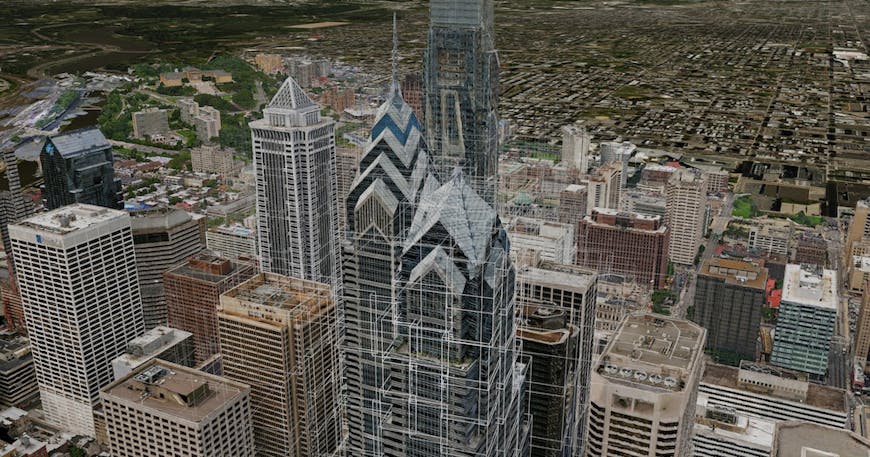
Cesium is an open platform to stream, visualize, and analyze 3D geospatial data. We take your raw 3D data, put it on the globe, and let you see it, interact with it, and share it. At the heart of our platform is 3D tiling, which transforms massive and diverse 3D geospatial data into streamable 3D content that can be used on any device, online or offline.
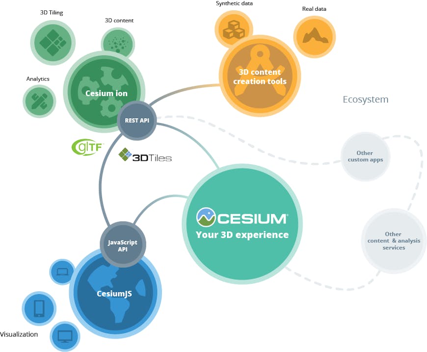
The Cesium platform..
We use leading techniques from computer graphics and geospatial to build Cesium and are building the Cesium platform for the long game. These principles are core to our vision:
- 3D from the ground up. 3D is not 2D + 1—it is not an afterthought. We live in a 3D world and that context deserves to be preserved to provide key spatial insights.
- Time-dynamic. Whether it’s a construction site or a rainforest, the same real-world location is often captured at different times, and understanding the change in the landscape is paramount. Our heritage of tracking objects through space and time extends to tracking landscapes and providing insights for any given (x, y, z, t).
- Precise. Whether you are measuring rooftops or predicting the future position of satellites, accuracy matters. We build precision into every component of our technology to ensure the accuracy of real-world data is faithfully represented.
- High performance. 3D geospatial datasets are among the most massive of big data, and performance is everything. We use cloud computing, parallel programming, and GPUs in everything we build.
- Customizable. 3D geospatial touches almost every industry, and we believe that every Cesium user should expect a highly tuned experience—not just a re-styling of the look and feel.
- Open. The unprecedented growth in 3D geospatial data has created enormous opportunity. We as an industry need to collaborate to move fast. We adopt, contribute to, and create open standards with industry consortiums to facilitate this collaboration and allow our platform to mobilize an ecosystem. The future is bigger than just Cesium, and we’re excited to play our part.
The future of 3D is data
From cameras and LIDAR on satellites, aircrafts, drones, cars, and IoT devices to AI-generated semantics to open data policies to crowdsourcing, 3D geospatial data is more easily available, at a higher resolution, and more frequently refreshed than ever before. Now this data needs to be made accessible, shareable, and ultimately usable.
Cesium does this with:
- BYOD. We’re a Bring Your Own Data platform. We empower organizations to interact with their data via robust and performant pipelines in the cloud or on private networks.
- Data partners. We collaborate with data partners, such as Vricon, to connect data and developers—and together build new 3D experiences.
- Curated data. By curating data, we form base layers, such as global terrain, that act as a canvas for developers to add additional data.
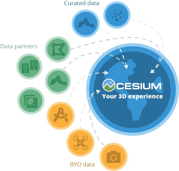
Data ecosystem.
This is about the ecosystem
We believe our commitment to open interoperability and collaboration with the open source community and commercial partners is the fastest way to move the field forward. Together, we will build an ecosystem. Collaboration with partners in specific industry verticals, where our 3D geospatial knowledge complements their domain knowledge, will be particularly valuable.
Whether you are building digital twins for smart cities, AI-powered drone data capture platforms, or mixed reality mission planning for the military, we are designing Cesium—and the ecosystem it enables—to be the foundation on which you can realize your vision with 3D geospatial data. We can’t wait to see where you take it.
How we’re building our company
Our vision for Cesium’s impact extends far beyond the Cesium platform to the many communities we participate in. In addition to building the best technology for 3D geospatial, we are building the best company we can—for ourselves and for our communities.
- Contributing back to open source: We contribute to many projects in the open source geospatial community and are active in 3D and graphics open standards communities.
- Belief in education: We teach courses at universities, present guest lectures and workshops, hire interns, present at conferences, and are always up for an opportunity to share what we’ve learned along the way.
- Growing the Philadelphia tech community: Philly is our home, and it’s a great place to live and work. It also has a vibrant startup and business network that we want to help grow and thrive.
- Social good: Among other initiatives, disaster response will benefit from the speed of our platform to go from data acquisition to situational awareness to timely support for first responders. We donate time and resources to give back for the social good.
Thank you
A big thank you to our users, to all Cesium contributors, our partners, our colleagues at AGI, and our friends and family who have helped us get here today. We couldn’t be more excited to focus now on building our platform, growing our team, and pushing the 3D geospatial ecosystem forward with our many friends and partners in this space.