Army Game Studio Using One World Terrain Data in Cesium for Unreal
The following is a guest post from Lysle Shields, Principal Software Engineer at Army Game Studio.
The release of Cesium for Unreal is connecting the worlds of geospatial entities and game engines, unlocking real-world content for game design and more.
Today the Army Game Studio (AGS), part of the Software Simulation, Systems Engineering and Integration Directorate (S3I), is making use of Cesium for Unreal for battlefield map and scenario rendering.
Image Generation with One World Terrain
Army Game Studio’s Image Generator (AGS IG) is a standalone Army-owned application, based on Epic Games’ Unreal Engine 4 game technology, which provides out-the-window and Electro-Optical / Infra-red (EO/IR) sensor simulation views for training products. With the advanced rendering capabilities of Unreal 4, Distributed Interactive Simulation (DIS) 6.0 Interface to control individual scene actors, and Common Image Generator Interface (CIGI) 3.3 to control camera orientation and HUD elements, the AGS Image Generator provides fully featured views into any world.
![Rendering of Fort Polk Louisiana Training Facility seen through Army Game Studio IG while controlled by MUSE/AFSERS software made by Joint Simulation Integration Laboratory [JSIL]](https://images.prismic.io/cesium/748b6a19-5d3a-444d-981e-bc819bf0569f_FortPolk1%20-%20Clipped.png?auto=compress%2Cformat&w=870)
Rendering of Fort Polk Louisiana Training Facility seen through AGS IG while controlled by MUSE/AFSERS software made by Joint Simulation Integration Laboratory [JSIL].
![Rendering of Fort Polk Louisiana Training Facility seen through Army Game Studio IG while controlled by MUSE/AFSERS software made by Joint Simulation Integration Laboratory [JSIL]](https://images.prismic.io/cesium/60096f17-fee9-4ff1-a795-c10d7ec87fef_FortPolk3%20-%20Clipped.png?auto=compress%2Cformat&w=870)
Rendering of Fort Polk Louisiana Training Facility seen through AGS IG while controlled by MUSE/AFSERS software made by Joint Simulation Integration Laboratory [JSIL].
Typically, geospecific maps for the AGS IG are created manually using Epic’s standard Unreal toolset. While this labor intensive process produces impressive results, the need for world-wide coverage during training required that additional functionality be added to the AGS IG to support a more automated approach for incorporating geospecific terrain formats.
To that end, Army Game Studio is continually updating the AGS IG to support the Army’s Program Executive Office Simulation, Training and Instrumentation (PEO STRI), evolving One World Terrain (OWT) 3D terrain data. The Army’s One World Terrain (OWT) delivers 3D global terrain capability and associated information services that support a fully accessible virtual representation of the physical Earth accessible through the Army network.
In the early days of experimentation with AGS IG, data was imported piece by piece from .OBJ files into Unreal maps. This provided high-fidelity maps but was still limited in the number of chunks of data that could be handled. While realistic maps were created from satellite imagery, the ability to scale up to larger maps was limited by the need to load and maintain large amounts of data directly in the Unreal Editor. These problems were solved by using the Cesium 3D Tiles data format and the Cesium for Unreal plugin.

AGS Image Generator using Cesium for Unreal to render Yuma Proving Grounds Arizona terrain.
Integration Demo
In 2020, the Army Game Studio participated in a demonstration highlighting the integration of multiple military technologies in a simulated battlefield exercise using Yuma Proving Grounds, Arizona terrain for the operational environment. During the exercise, networked views were provided from a MQ-1C Gray Eagle RPA (Remotely Piloted Aircraft), a RQ-7B Shadow RPA, and a UH-60M Black Hawk helicopter. The two RPAs were simulated using MUSE/AFSERS software from the Joint Systems Integration Lab (JSIL) and provided surveillance views of the area. The Black Hawk simulation was provided by Training Aids, Devices, Simulations, and Simulators (TADSS) using the Cockpit Academics Procedural Tool - Enhanced with Visuals and Control Loader System (CAPT-EVCS) from the U.S. Army Combat Capabilities Development Command Aviation and Missile Center (DEVCOM AvMC) Crew Station Working Group (CSWG) and Program Executive Office, Aviation (PEO-A) Utility Helicopters Project Office (UHPO).
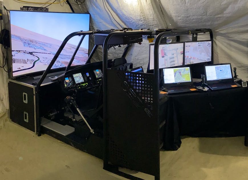
AGS Image Generator using Cesium for Unreal with CAPT-EVCS and JSIL MUSE/AFSERS.
With a pre-release version of Cesium for Unreal, Army Game Studio was able to use the AGS IG to render a 100 x 100 km terrain map of Yuma, Arizona provided by One World Terrain directly in Unreal at 60 Hz on an 80” 4K display using standard NVIDIA RTX 2080 gaming hardware. An example of the terrain is shown in this video.
Army Game Studio used AGS IG to render a terrain map of Yuma, Arizona provided by One World Terrain directly in Unreal.
The demonstration was a success thanks to the dedicated work of everyone involved by using the AGS IG Unreal development technology with the new Cesium for Unreal plugin. Cesium for Unreal allowed an easy integration and provided a way to rapidly stream large terrain databases in the needed format, at the required resolution, while maintaining a high frame rate.
For more information about the AGS IG, contact Michael Barnett at michael.w.barnett.civ@mail.mil
Cesium for Unreal is available for free download on The Unreal Engine Marketplace.