Purdue University Exploring the Boundaries of XR with Cesium
Purdue University’s Envision Center supports faculty across the university by creating 3D visualizations for research and classroom use. When researchers requested an immersive way of viewing complex spatial data, such as supernovas, heart models, and combustion engines, the Envision Center built CollabXR, a collaborative XR platform designed to ingest nearly any 3D dataset and explore it as a group. Now with the addition of Cesium for Unity, CollabXR supports geospatial data as well.
CollabXR, built by the Envision Center at Purdue University, allows people to explore complex 3D data in VR together as a group. Now with the addition of Cesium for Unity, they can also visualize geospatial datasets. Courtesy Purdue University.
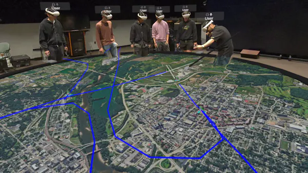
Originally developed as a shared model viewer, CollabXR has grown into a multipurpose XR environment that supports visualizations ranging from astronomy and geoscience to cultural heritage and aviation safety. The platform runs on Meta Quest, Apple Vision Pro, and desktop systems, supporting both fully immersive VR and mixed reality.
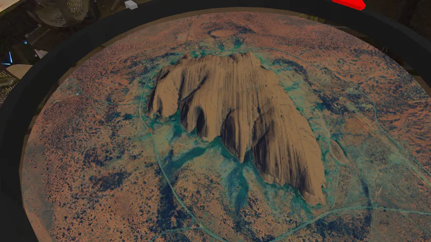
Uluru in Australia, visualized with Cesium for Unity in CollabXR. The Purdue University Envision Center team has built an app that allows students to explore Earth using Google Photorealistic 3D Tiles. Courtesy Purdue University.
The CollabXR platform allows multiple users to engage with a single VR experience. Multi-user synchronization is handled through a networked architecture, while Unity performs client-side rendering and interaction, enabling participants to annotate, draw, and manipulate data together in real time.
“CollabXR has allowed us to bring in nearly any type of 3D model, but we’ve always wanted to be able to view geoscience data. With Cesium for Unity we’ve expanded the capabilities of CollabXR for earth and planetary sciences, cultural heritage, history, aviation, and other areas. Combining 3D Tiles with live feeds such as aviation ADS-B data, we are able to create holographic geospatial digital twins.”
– George Takahashi, Principal Visualization Scientist, Envision Center, Purdue University
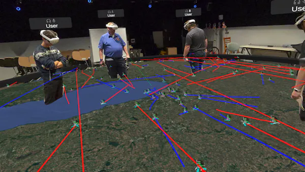
The Envision Center has brought a live ADS-B feed into CollabXR, allowing viewers to see live flights, like this visualization at the Chicago O’Hare Airport. Courtesy Purdue University.
Users of CollabXR can manipulate data in the environment. Here, a student pilot is landing a plane showing live tracked data from the university’s local Lafayette Regional Airport. Courtesy Purdue University.
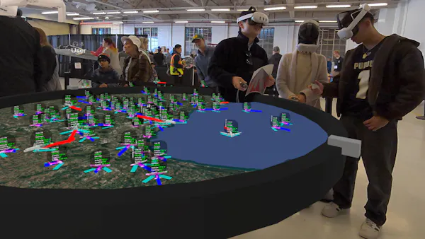
On Purdue Aviation day, over 200 visitors engaged with live aviation data through CollabXR. Courtesy Purdue University.
Since integrating Cesium for Unity, the Envision Center has been able to add geospatial visualization to their repertoire. Cesium provides a high-accuracy WGS84 globe and streams real-world terrain and photogrammetry at runtime using open standards like 3D Tiles. This allows researchers to anchor domain-specific data, such as satellite orbits, atmospheric models, or live aviation feeds, directly to Earth and explore everything from city-scale sites to planet-scale environments within a single XR experience.
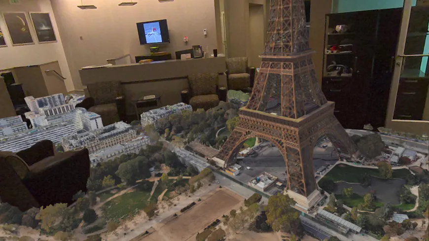
Google Photorealistic 3D Tiles of the Eiffel Tower in Paris, France, visualized with Cesium for Unity in CollabXR. The team built a demo visualization showing points of interest around the world. Viewers can interact with the geospatial data, highlighting key areas. Courtesy Purdue University.
Cesium’s streaming architecture makes it possible to visualize massive geospatial datasets on lightweight head-mounted devices without custom pipelines for each discipline. For students and developers, Cesium’s integration with Unity Game Objects and workflows has proven highly approachable: the majority of the artwork and code for each visualization produced by the Envision Center is done by undergraduate students, guided by a small core engineering staff.
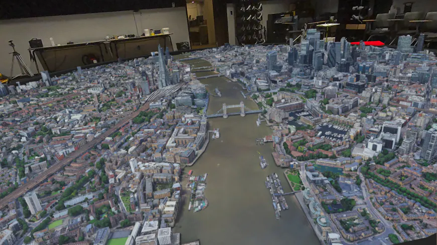
Google Photorealistic 3D Tiles of London, England, visualized with Cesium for Unity in CollabXR. Faculty leading students on international experiences have used visualizations like this to preview trips for students before they go. Courtesy Purdue University.
The Envision Center is part of the Rosen Center for Advanced Computing, which operates the centrally maintained research computing resources at Purdue University. They’re dedicated to assisting, supporting, and collaborating with faculty, students, and industry in scientific visualization, virtual and augmented reality, and media creation. The center’s staff and student employees work with faculty partners and external clients to create VR and data visualization tools for research and educational use. The center also collaborates on grant proposals and develops promotional media, such as publication-quality stills and animated videos.
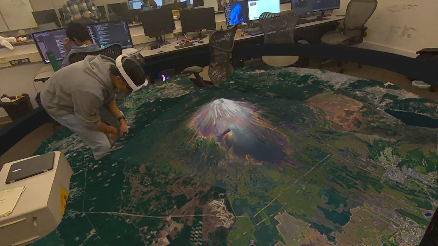
Google Photorealistic 3D Tiles of Mt Fuji, Japan, visualized with Cesium for Unity in CollabXR. Student observation of 3D geosciences, topography, and tectonic data enhances spatial exploration and communication. Courtesy Purdue University.
CollabXR is being prepared for open source release, with the goals of lowering the barrier for other universities and research groups to create shared XR environments and of expanding the reach of CollabXR use cases. By combining Unity’s XR ecosystem with Cesium’s high-accuracy geospatial platform, the Envision Center at Purdue University has created a flexible foundation for spatial computing to meet advanced research needs. To create your own real-world visualizations in XR, try out Cesium for Unity.