WSB Transforms Constructability Reviews with Cesium and 3D Tiles in Bentley Infrastructure Cloud Connect
The most costly risk to major infrastructure projects isn't bad weather or poor funding: it's the risk that slips past the constructability review. If not caught soon enough, a single contradiction—like major utility conflicts or an unworkable traffic management plan—triggers millions in wasted taxpayer funds and guarantees years of delay.
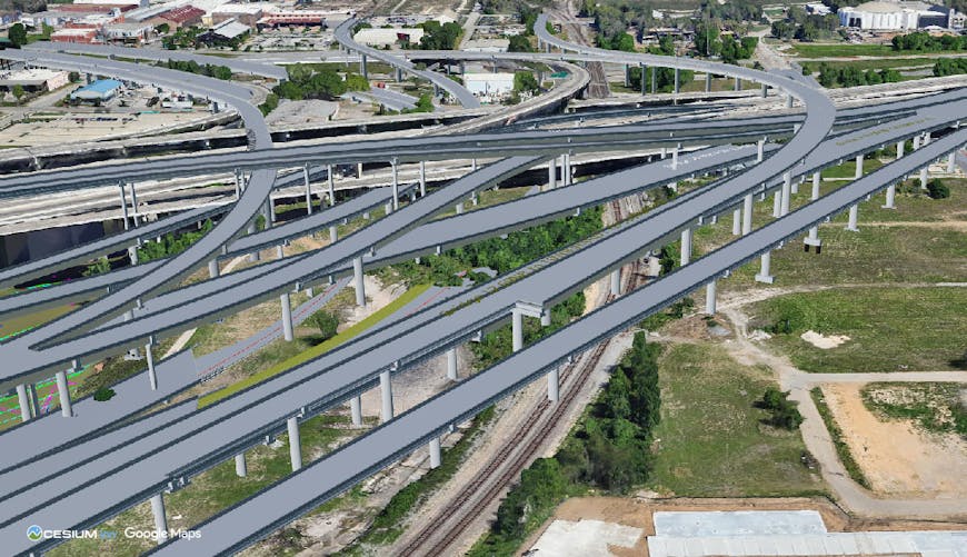
A critical conflict revealed during constructability review: a proposed highway support column lands directly on existing railway tracks. Courtesy WSB.
Although the constructability review is the critical gatekeeper, the process is often trapped in 2D static documents. Engineering design and consulting firm WSB is using Cesium-powered geospatial capabilities in Bentley Infrastructure Cloud Connect to ensure design flaws are caught early.
Connect provides a secure, open, and scalable environment for engineering services firms, construction firms, and owner-operators to store, manage, and share infrastructure files and data. Cesium’s integration with Connect offers a unified web experience to visualize infrastructure data in full geospatial context.
“Civil engineering isn’t just about technical analysis—it’s also about solving geospatial challenges,” said Andy Kaiyala, vice president of digital construction management at WSB. An early adopter of Connect, Kaiyala adds “Cesium’s capabilities allow us to incorporate critical spatial information early in the process, helping us make smarter decisions about fitting infrastructure into available space while minimizing disruption.”
Demonstration showing Cesium’s integration with Bentley Infrastructure Cloud Connect.
CesiumJS serves as Connect’s visualization front end, rendering massive infrastructure datasets on an interactive map that scales from a global portfolio view—covering multiple projects across regions—down to detailed, project-level insights. Engineering-grade data (such as BIM models, point clouds, and reality meshes) is efficiently streamed as 3D Tiles, the Open Geospatial Consortium (OGC) community standard created by Cesium. Connect also integrates Google Photorealistic 3D Tiles, leveraging the 3D Tiles standard to provide high-resolution 3D representations of major cities and terrain.
Apart from catching obvious errors, Cesium’s geospatial capabilities in Connect help teams uncover hidden, high-impact risks that traditional reviews miss. On a project in the southern United States, WSB quickly identified and effectively communicated a high-risk design problem: a proposed railroad bridge and major sewer infrastructure were planned adjacent to a protected historic building, prompting a redesign before the project moved to final design —and potentially saving months in schedule delay and millions in public funds.

Cesium-powered geospatial capabilities in Connect reveal design conflict between a proposed railroad bridge and a historic building. Courtesy WSB.
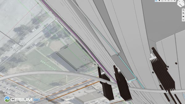
A bottom-up view highlights further design conflict between sewer pipes and the proposed bridge pilings. Courtesy WSB.
“Cesium provides a high-performance, scalable, and geospatially accurate environment that brings full context to infrastructure project designs in Connect,” said Bill McNamara, senior director of iTwin and portal experience at Bentley. “It’s not just empowering our end users. It’s driving value across the ecosystem of infrastructure stakeholders.”
While testing the Cesium integration with Connect, WSB shared curated views of 72 projects with over 900 external stakeholders representing 86 organizations, including state departments of transportation, rail authorities, utilities, and public agencies. “We can bring more stakeholders to the review process earlier, thanks to the intuitive way Cesium enables us to visualize project designs. It’s become a key differentiator for us,” Kaiyala explained.
“When we show a design model with a 2D map, stakeholders nod politely,” added WSB director of digital construction management strategy Corey Johnson. “But when we show it on an interactive Cesium-powered map surrounded by Photorealistic 3D Tiles, their eyes light up. They immediately understand the proposed design and any constructability issues.”
For WSB, visualizing engineering data in true geospatial context has elevated constructability reviews from a static checkpoint to a dynamic driver of smarter, faster, and more transparent project delivery. As more organizations adopt Cesium-powered capabilities in Connect, early detection and clear communication of design risks resolve conflicts before shovels hit the dirt. Kaiyala summed up the approach: “Ultimately, Cesium isn’t about pretty pictures; it’s about putting valuable information in the hands of the people who build the infrastructure we all rely on.”
Sign up for a free Cesium ion account to pair your 3D models with accurate geospatial context.