MicroStation Advances Infrastructure Design with 3D Tiles
From roads and bridges to campuses and cities, infrastructure design relies on precise geospatial context. With its 2025 release, MicroStation—Bentley Systems’ flagship computer aided design (CAD) software—introduced support for Open Geospatial Consortium (OGC) 3D Tiles using Cesium Native to efficiently deliver that context to professionals worldwide. This integration also makes MicroStation the first CAD software to support Google Photorealistic 3D Tiles.
MicroStation is a foundational software application for infrastructure design, central to thousands of landmark projects. It’s trusted by architects, engineers, designers, drafters, and BIM managers to design, manage, and efficiently deliver infrastructure projects. Professionals across transportation, energy, utilities, construction, government, and campus and facility management sectors rely on MicroStation to bring their vision to life.
The software has played a central role in countless notable infrastructure projects worldwide. Examples include London’s Crossrail Elizabeth Line, New York’s Governor Mario M. Cuomo Bridge, and the Sydney Airport. It was also recently used by Italian engineering firm Italferr to create a highly detailed digital twin of St. Peter’s Basilica to preserve its architectural and cultural significance.
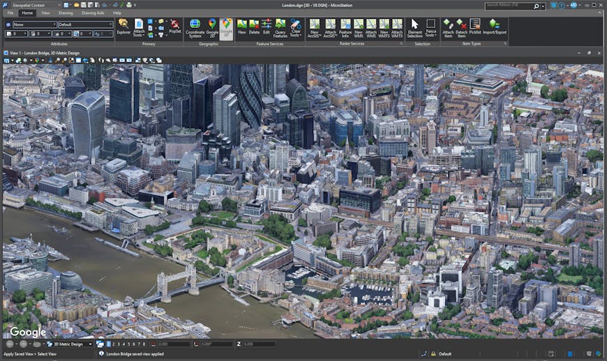
London, UK, rendered with Google Photorealistic 3D Tiles in MicroStation.
Integrating 3D Tiles enables efficient streaming and visualization of massive geospatial datasets providing highly accurate real-world context within MicroStation. With the latest MicroStation release, users can now bring Google Photorealistic 3D Tiles and engineering-grade reality data formatted as 3D Tiles via Bentley iTwin Reality Management directly into their designs.
“Support for 3D Tiles in Bentley’s MicroStation is a major step forward for the open geospatial ecosystem. It brings the 3D Tiles open standard into the hands of infrastructure professionals worldwide and unlocks new use cases across industries,” said Patrick Cozzi, Bentley chief platform officer and Cesium founder.
Photorealistic 3D Tiles are a 3D mesh textured with high-resolution imagery, available for 2,500 cities and 49 countries, bringing real-world data to infrastructure visualizations. By replacing manual workflows for modeling and detailing existing environments, infrastructure professionals can focus their time on the proposed designs. This shift has led to major time savings: Tasks that previously consumed over 1,000 hours for long linear projects can now be completed in as little as 200-300 hours.
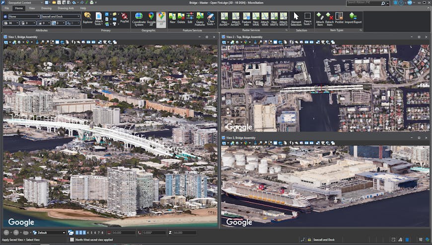
Google Photorealistic 3D Tiles of the 17th Street Causeway Bridge, Fort Lauderdale, Florida, USA, seen through multiple viewports viewed in MicroStation.
This integration also marks the first Bentley application to use Cesium Native—a collection of high-performance C++ libraries designed for 3D geospatial applications. Cesium Native includes 3D Tiles runtime streaming, lightweight glTF serialization and deserialization, high-precision geospatial math types and functions, and support for a wide range of geospatial standards.
To support MicroStation specifically, new capabilities were added to Cesium Native, including multiple viewport support and orthographic camera functionality. These features are now also available in Cesium for Unreal and will be added to other Cesium Native integrations based on the community’s interest.
Pairing 3D Tiles and Cesium Native with MicroStation illustrates our commitment to expanding and strengthening the open geospatial ecosystem, creating new opportunities for developers and empowering users to design, manage, and deliver better, more resilient infrastructure.
Bring detail and efficiency to your infrastructure projects with 3D Tiles.