The Geospatial Revolution Is Open: How Developers Are Transforming the Landscape
At the upcoming Cesium Developer Conference Geospatial World will spotlight emerging trends and the transformative role developers continue to play in the open geospatial ecosystem. We will explore how developer-led innovation is unlocking new economic opportunities, advancing sustainability, and shaping the digital infrastructure of tomorrow.
The Rise of the Geospatial Economy
Geospatial technologies—once confined to scientists and specialized industries—are now deeply woven into the fabric of everyday life. From ridesharing and food delivery to disaster response, climate monitoring, and urban infrastructure, geospatial data powers an expanding array of essential and commercially valuable services. In fact, the geospatial market is projected to grow from USD $661 billion in 2025 to approx. USD $1.2 trillion by 2030, growing at a compound annual growth rate (CAGR) of 12.5%.
This growth is not monolithic; it reflects the differentiated roles of distinct technological verticals (see Figure 1). Global Navigation Satellite System (GNSS) and positioning, for example, is expected to more than double in size from 2022 to 2030—driven by its pivotal role in real-time navigation, autonomous mobility, and synchronized telecommunications. Meanwhile, GIS and spatial analytics are forecasted to grow from USD $111 billion to USD $263 billion, fueled by accelerating use cases in smart city design, precision agriculture, infrastructure management, and environmental, social, and governance (ESG) compliance.
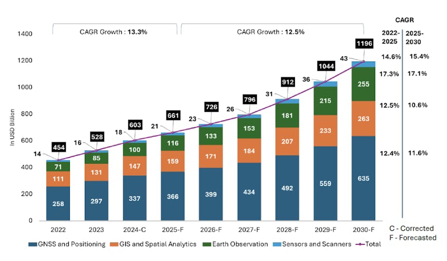
Figure 1: Global Geospatial Market Size and Forecast (2022-2030). Source: Geospatial Knowledge Infrastructure Readiness Index 2025 by Geospatial World.
Looking ahead, the industry is undergoing a structural shift toward Geospatial Knowledge Infrastructure (GKI)—a knowledge-led, integrated paradigm that positions spatial data as a strategic asset at the heart of digital economies.
At the same time, macroeconomic and policy drivers—sustainability mandates, climate resilience goals, and data sovereignty concerns—as well as the rise of generative AI, are converging to elevate the importance of open systems. Capitalizing on this transformation requires open geospatial ecosystems: well-managed open data platforms, clear interoperability policies, customizable tools, and robust regulatory frameworks.
Hence, open-source geospatial tools are no longer niche alternatives; they are becoming foundational. Their flexibility, cost-efficiency, and adaptability make them ideal for a broad range of users, from startups and municipalities to national governments. Supported by thriving commercial ecosystems—consulting, subscriptions, and “X-as-a-service” models—open systems are fundamentally reshaping how geospatial value is created, delivered, and scaled.
Developers: Catalysts of Open Innovation in Global Geospatial Industry Growth
Central to this shift is a global, self-organized community of developers. Developers are a critical driving force behind the growth of the geospatial industry, particularly through their role in cultivating and expanding open ecosystems. By building, contributing to, and integrating with open-source platforms (such as QGIS, GeoServer, Cesium), APIs, and developer tools, they create a foundation for scalable innovation and interoperability across sectors. This open ecosystem approach accelerates product development cycles, reduces barriers to entry, and fosters collaborative innovation, enabling organizations to build on shared standards and community-driven advancements.
As developers harness frameworks to create novel, high-impact geospatial applications—climate modeling and smart city infrastructure to disaster response and precision agriculture—they dramatically expand the accessibility and utility of geospatial technologies. These innovations not only increase platform usage and enable new commercial models but also generate significant socioeconomic value by empowering public institutions, startups, and underserved communities with actionable spatial intelligence, thus growing the geospatial market significantly.
Building Resilience Through Open Standards
A core strength of the open geospatial ecosystem lies in its interoperability. Developers work with widely adopted standards (e.g., GeoJSON, KML, GML, and Open Geospatial Consortium (OGC) protocols) to ensure seamless data exchange between tools and platforms. This adherence to open formats avoids vendor lock-in and lays the foundation for resilient, future-proof systems. Community contributions, from bug fixes to localization efforts, accelerate the evolution of tools and ensure they remain responsive to real-world needs, especially in under-resourced environments.
From Code to Community Impact
Developers are going beyond being technologists; they are often on the front lines of digital inclusion. Working with incomplete or unstructured datasets, they collaborate with grassroots organizations to turn data into insight, often in regions where institutional support is minimal or nonexistent.
Civic tech movements like Code for America and Code for Kenya have mobilized developers to build tools that visualize budget data, improve healthcare access, and simplify the delivery of social services. The Humanitarian OpenStreetMap Team (HOT), a globally distributed network of mappers and developers, has been instrumental in crisis zones. After the 2015 Nepal earthquake, thousands of volunteers mapped roads and relief centers within hours, enabling more efficient aid delivery by organizations like the Red Cross.
Environmental initiatives have also benefited. The Mapati Project, which uses urban tree mapping to combat heat islands, and Global Forest Watch, which tracks deforestation in real time, both rely on open data and developer-built platforms. These tools give communities, indigenous groups, and environmental watchdogs the ability to hold actors accountable and participate in global sustainability efforts.
If the geospatial industry is to realize its projected USD $30 trillion economic impact, the strategic role of developers cannot be overstated. Beyond technical implementation, developers act as enablers of last-mile connectivity, translating complex geospatial capabilities into accessible, localized, and scalable solutions. Their work fuels the creation of real-time applications, dynamic decision-support systems, and data-driven public services that directly influence livelihoods, infrastructure, and policy outcomes. By bridging the gap between high-resolution data and community-level impact, developers transform code into catalysts for economic inclusion, environmental resilience, and societal progress.
Challenges Ahead and the Evolving Role of Developers
Despite the clear opportunity, the open geospatial community faces persistent challenges. Maintaining open-source tools often depends on volunteer labor. Questions of data privacy, ethics, and unequal access—particularly in developing regions—remain pressing concerns. The geospatial industry is also expanding faster than the talent pool can support, creating a widening skills gap. This signals a growing opportunity for the developer community not only to meet demand but to shape it—welcoming a broader, more diverse range of contributors, including designers, civic activists, and even artists. As generative AI and machine learning become central to geospatial workflows, the role of the developer is even more critical to open geospatial ecosystem innovation. No longer confined to code, developers are becoming interpreters of complex data, translating geospatial intelligence into socially meaningful outcomes.
Connect with developers and integrators shaping the future of open geospatial at the 2025 Cesium Developer Conference, and hear from Geospatial World, this year’s knowledge partner. Register to join us in Philadelphia in June.