Esri and Cesium Collaborations
At Cesium, we believe that collaboration is the key to advancing the 3D geospatial ecosystem for the benefit of all. For over a decade, we have supported interoperability with leading GIS providers like Esri to meet the growing need for comprehensive solutions that represent the natural and built environment with reality capture models, BIM/CAD designs, and traditional GIS layers.
3D Tiles support for Esri products, and collaboration with Esri and standards organizations like the Open Geospatial Consortium ("OGC"), enables users to find the best solutions for their geospatial use cases.

Collaboration enabled with OGC standards like 3D Tiles and I3S to support streaming, analyzing and creating 3D geospatial content and applications.
Esri ArcGIS helps users solve complex GIS problems to show hidden patterns, trends, and relationships. Combining this with efficient streaming and 3D visualization capabilities enables users to build solutions delivering advanced spatial data management and analysis.
The combination of GIS and 3D streaming capabilities can address a number of cases in the rapidly growing area of digital twins. For example, a design firm that is creating a spatially accurate 3D representation of a proposed project that includes utility, traffic, and zoning information can share multiple versions of their detailed architectural models to collect public feedback. Or a community group building a virtual experience of their city can combine 3D buildings with route planning to key landmarks or locations. Facilitated by open standards like 3D Tiles and Indexed 3D Scene Layers (I3S), Esri and Cesium are helping users unlock geospatial insights, increase access to spatial data, and empower a large and diverse community of users.
Below are some examples:
Last fall, Esri announced the integration of 3D Tiles into the ArcGIS System of Record as a way of enhancing 3D GIS workflows. This integration allows users to combine 3D Tiles with other OGC community standard GIS layers, such as Indexed 3D Scene Layers (I3S), for use in exploration tools, analysis, animation, layouts, and more. With 3D Tiles seamlessly integrated, users can elevate their data beyond a realistic visualization by leveraging the analytic power of a complete GIS.
ArcGIS Reality for ArcGIS Pro and Drone2Map can be used to process aerial and drone imagery to create full resolution Digital Surface Models (DSMs), true orthos, and 3D point clouds, as well as 2D meshes and photo-realistic 3D meshes that can be exported as 3D Tiles.
With ArcGIS Pro, users can visualize 3D Tiles layers together with other 2D or 3D layers, view layers with different spatial references together, drape 2D layers on top of 3D mesh layers, and edit features based on 3D Tiles layers. With 3D Tiles layers, users can now interactively analyze scenes and perform exploratory analysis like viewsheds and view domes. ArcGIS Pro also allows users to share 3D Tiles layers from a scene to ArcGIS Online.
Users can integrate 3D Tiles integrated mesh layers into Scene Viewer. Like the existing Integrated mesh scene layer, a 3D Tiles integrated mesh layer can represent built and natural environments through realistic textures and elevation information and be used in combination with other geospatial content.
Along with other OGC Services, users can add 3D Tiles as a local tileset or via a hosted service in ArcGIS Online or third party web servers to ArcGIS Earth, Esri’s free application for visualizing and exploring geospatial content in 3D.
Both the 200.4 release of the ArcGIS Maps SDKs for Native Apps and the 4.29 release of the ArcGIS Maps SDK for JavaScript adds support for 3D Tiles. These features allow developers to leverage the power of the Open Geospatial Consortium (OGC) 3D Tiles format, providing a seamless integration of yet another type of 3D geospatial data into their custom applications.
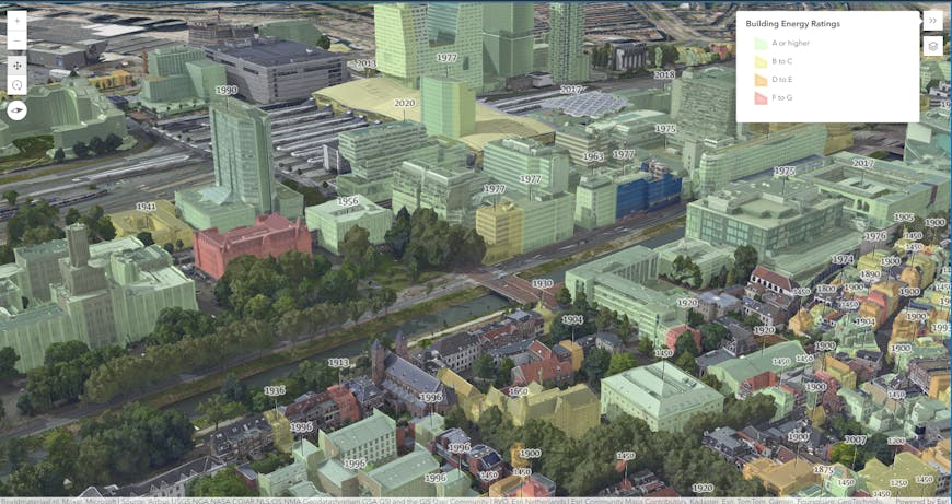
ArcGIS Scene Viewer with 3D Tiles with draped graphics for relative energy ratings and labels for construction years for buildings in the city Utrecht - from Esri Developer IntegratedMesh3DTilesLayer sample application - https://developers.arcgis.com/javascript/latest/sample-code/layers-integratedmesh3dtileslayer/live/
Open and connected APIs and data services from other providers help to unlock the value of the 3D geospatial ecosystem. Cesium has long-supported the integration of ArcGIS Terrain, Imagery, and Map services within CesiumJS.
Recently, Esri collaborated with Cesium to enable Indexed 3D Scene Layers (I3S) within CesiumJS. This open source contribution from Esri brings extensive collections of I3S content from ArcGIS to CesiumJS developers and users. I3S, an OGC standard, facilitates the efficient transmission of various 3D data types, including discrete 3D objects with attributes, integrated surface meshes, and point cloud data across vast areas, as well as detailed Building Information Model (BIM) content. This capability supports delivery to web browsers, mobile apps, and desktop environments. Currently, the I3S integration into CesiumJS supports 3D Objects, Integrated Mesh, and Building Scene Layer data types, enabling the integration of 3D and 2D data from multiple sources, including Cesium ion and ArcGIS Online, into a single geospatial application.
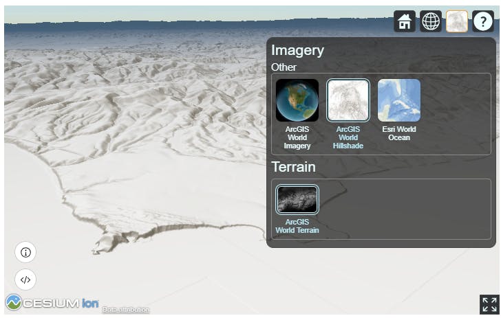
ArcGIS Terrain and Basemaps in Cesium ion as shown in Esri Developer Tutorials
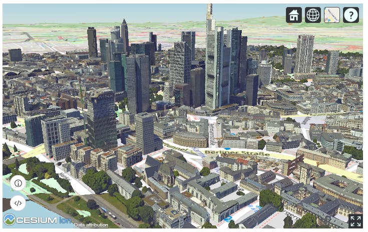
ArcGIS I3S Services, ArcGIS Basemap and Cesium World Terrain as shown in Esri Developer Tutorials
Another layer of integration between the ArcGIS and Cesium platforms is at the developer level where we have collaborated to bring ArcGIS Location Services and the ArcGIS Maps SDKs into CesiumJS. ArcGIS Location Services provide services for building mapping and spatial analysis applications, available as part of ArcGIS. The inclusion of the various ArcGIS APIs is another step in the multi-year effort to steadily add open source support for ArcGIS APIs, data, and services to CesiumJS.
Additionally, Esri’s Developer site provides over 20 tutorials showing users how to integrate ArcGIS locations services and CesiumsJS. Through this collaboration, CesiumJS users can combine ArcGIS location services and Google Map Platform’s Photorealistic 3D Tiles to quickly and easily create powerful 3D geospatial visualizations.
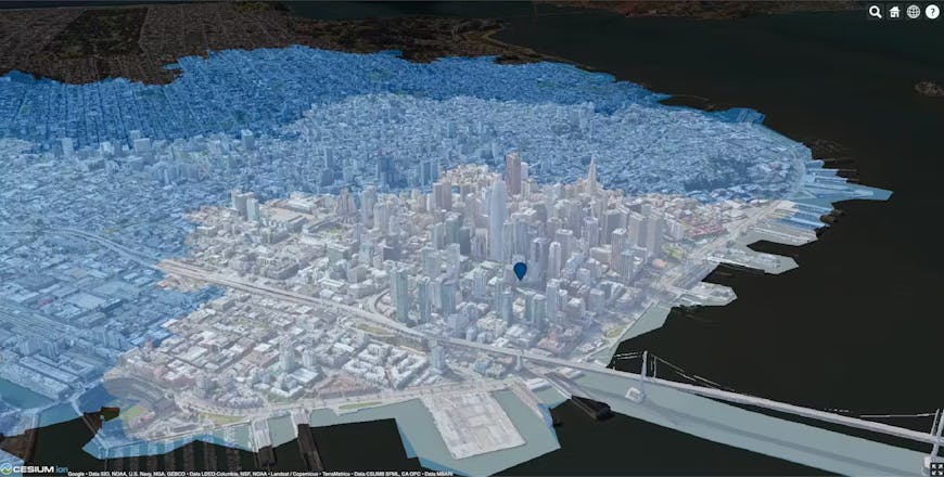
Esri Location Services with Photorealistic 3D Tiles from Google Maps Platform streamed into CesiumJS
See the reference materials for more info. As we begin the next chapter at Cesium, open standards remain at our core. We look forward to continuing to collaborate with industry leaders like Esri to offer additional value and capabilities to the 3D geospatial community.
If you have ideas about integrations between Cesium and Esri or other third party organizations, please share them on the Cesium Community Forum.
Updated 10/04/2024 to include ArcGIS Maps SDK for JavaScript