東京都デジタルツイン3Dビューアは Cesiumを活用し、「都民生活の質の向上」を守る
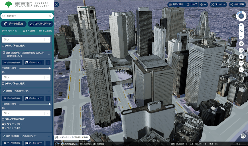
1,400万人を超える日本最多の住民を抱える東京都は、デジタルの力で東京のポテンシャルを引き出し、都民の生活の質の向上(クオリティ・オブ・ライフ:Quality of Life、以下QoL)のため、東京都全体のデジタルツインの社会実装を目指しています。都庁は都市のデジタルツインを3つの柱、「データ整備」「データ可視化」「データ解析」と定義、この3つの柱を3D地理空間プラットフォームの活用で連携させ、利用者に最も体験を提供しやすい「データの可視化」に先駆けて取り組みました。「データの可視化」は、都民や企業、各行政を含めた利用者とともに都市を創っていくために必要な共通認識や合意形成を図るうえで非常に重要と判断したからです。その結果、2021年に都庁のデジタルツインの世界を3D地理空間情報の可視化で体現する「東京都デジタルツイン3Dビューア」を生み出し、現在では自治体を超えた多くの行政・企業・市民からの利用が進んでいます。ここで3Dビューアの基盤として利用されているのがCesiumプラットフォームです。
Cesiumは海外諸都市ですでに利用実績も多く、CityGMLやLASといった様々な3Dデータ形式を3Dタイルに変換しストリーミング用に最適化し、属性データを保持して可視化できる点、グローバルレベルで地形、画像、写真測量データなど実世界の3Dコンテンツが豊富な点、Web上で可視化され誰でも利用できる点、などが評価され採用されました。
さらに、大量の点群データの3Dタイルへの変換は、すべてCeisum ionのタイル変換機能が利用されています。また、庁内環境の地形データ配信を行うCesium ion Asset Serverや、外部へのデータ公開もCesium ionで実現されています。
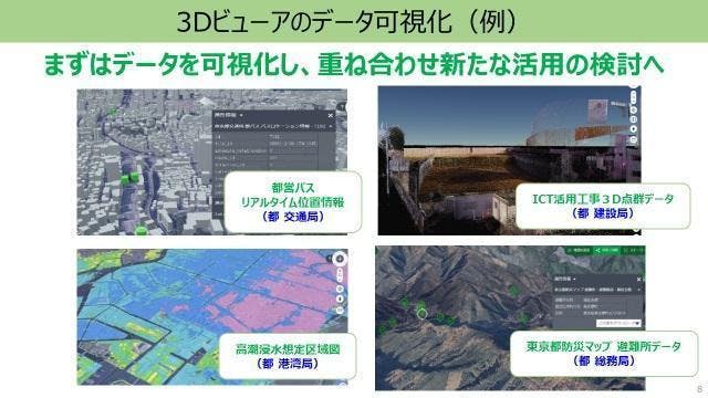
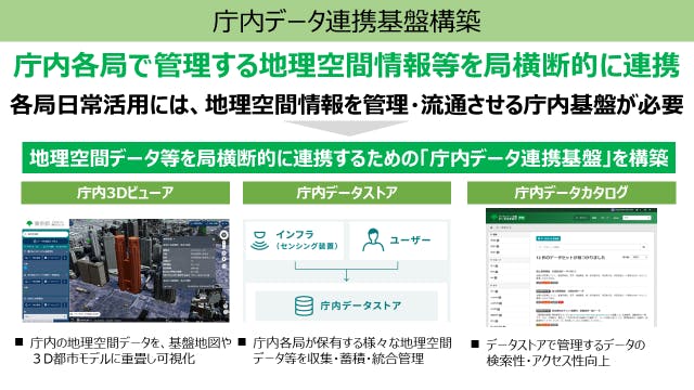
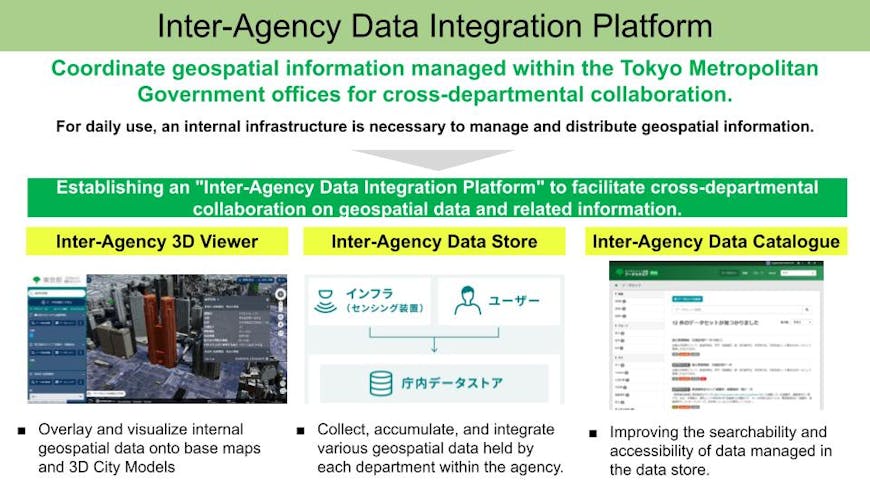
これらのリアルタイム情報をさらに都民への迅速で正確なサービスに繋げるため、都庁内DXの一環として庁内に分散していた様々な形式の地理空間データの整備を進め、庁内・庁外のリアルタイムデータのCesiumベースでの3Dビューアへの反映と、各種サービスの創出につなげています。
高精度の視覚化・リアルタイムデータをもとに、利用者とインタラクティブに創造する都市づくりを目指す
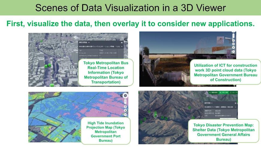
現在Cesiumの利用をもとに、東京都デジタルツイン3Dビューアでは、地形データが25cm精度の詳細なものとなっており、日本のジオイド2011に基づいて変換しているため、高い垂直方向の精度を実現しています。また、自動車のセンサーデータ、交通量調査ビデオからAI解析した交通量データの可視化を官民で試行しています。
さらに、災害多発国日本での都市のQoLを守るため、最大の注力領域の一つである防災分野では、防災に関するリアルタイムデータを充実させ、災害発生時に都外の他の地域にも及ぶ広域支援も実施しています。
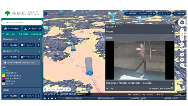
例えば水害時には、予想される氾濫時の浸水エリア、海の近くでは高潮による被害想定、地形データ、避難所などの情報を一元的に可視化し防災対策を立てやすくしています。また、実際の豪雨時には、河川のリアルタイムデータ(水位、雨量、ライブカメラ、警報の発令状況)、高潮に関するリアルタイムデータ(水門付近の水位、ライブカメラ)を一元的に可視化、発信することで、都民が迅速に現状把握し、早めに避難行動に移れるようにしています。
様々な可視化を実現しインタラクティブなサービスを目指す
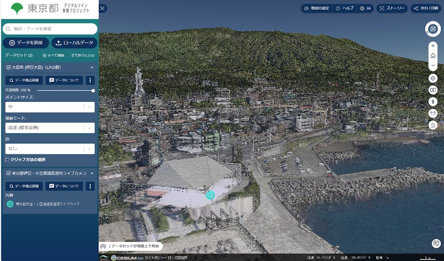
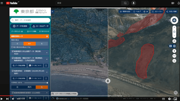
また、日本は世界有数の地震の多発国ですが、東京都として、今回の能登半島地震で被災前のデータと被災後のデータを掲載することで早期の復興対策を支援しています。測量のもとになる精緻なデータとして緯度・経度・高さ・色情報を有する点群データを使用し、被災前の点群データやそれをもとにした地形データを3Dビューアに掲載、被災後の斜面崩落に関するデータと重ね合わせることで、被害状況の把握や復旧・復興活動の迅速化を支援するものです。
東京都庁は、日本における3D地理空間情報の第一線の使い手として、「東京都デジタルツイン3Dビューア」をデジタルツイン実現の軸と位置づけ、都市の災害に対する強靭化や都民のQoLの向上をさらに進化させ続けています。私たちCesiumは、東京都庁のこのような取り組みを支援できたことを誇りに思います。
CesiumJS を使用して独自のインタラクティブな Web アプリを構築するには、ラーニング センターのガイドをご参照ください。また、Cesium ionを使用すると、世界中の地形、画像、建物を含む実物大の地球に独自のデータを取り込むことができ、Cesiumの 3D タイル パイプラインは、データセットの大きさに関係なく、ストリーミング用にデータを最適化します。ぜひ無料のCesium ionアカウントにサインアップしてお試しください。また、独自の環境で3Dコンテンツの作成とホスティングを開始する場合はCesium ion Self-Hostedサービスを是非トライしてみてください。
Tokyo Metropolitan Digital Twin 3D Viewer Uses Cesium to Improve Quality of Life for Residents
"The Tokyo Metropolitan Digital Twin 3D Viewer” enables overlaying various types of data, including 3D city models, 3D point cloud data within the city, location information of Tokyo Metropolitan buses, river data, various 2D data, and videos, in addition to the 3D city model. CesiumJS and Cesium ion are utilized as the visualization infrastructure for that 3D viewer.
Tokyo, which has the largest number of residents in Japan with over 14 million people, aims to unleash Tokyo's potential through the power of digital technology, and to achieve the social implementation of a digital twin for the entire Tokyo metropolis, aiming to improve the quality of life (QoL) for its residents.
The Tokyo Metropolitan Government (TMG) has defined three pillars for the city's digital twin: "data organization," "data visualization," and "data analysis." It has proactively addressed "data visualization," which offers users the most accessible experience, by integrating these three pillars through the utilization of a 3D geospatial platform. This is because the TMG has deemed "data visualization" to be extremely important in fostering a common understanding and consensus among users, including citizens, businesses, and various administrative entities, in order to collectively shape the city. As a result, in 2021, the TMG created the 'Tokyo Metropolitan Digital Twin 3D Viewer,' which embodies the world of the metropolitan government's digital twin through the visualization of 3D geospatial information. Currently, there is increasing utilization of this viewer from a wide range of administrations, businesses, and citizens beyond municipal boundaries. The Cesium platform serves as the foundation for this 3D viewer.
Cesium has been widely adopted in various cities overseas, with numerous successful implementations. It is praised and adopted for its ability to convert various 3D data formats such as CityGML and LAS into 3D Tiles, optimizing them for streaming while retaining attribute data for visualization. Additionally, its rich availability of real-world 3D content such as terrain, imagery, and photogrammetry data at a global level, along with its accessibility for visualization on the web, has been recognized and embraced as well.
Furthermore, the conversion of large point cloud data into 3D Tiles is all handled by Cesium ion's tile conversion functionality. In addition, Cesium ion Asset Server, which delivers terrain data for the interior environment of the TMG, and external data publication is executed through Cesium ion.
As part of the TMG's internal digital transformation efforts, various formats of geospatial data dispersed within the government offices are being organized to further connect real-time information to swift and accurate services for the citizens. This initiative aims to reflect both internal and external real-time data onto a 3D viewer based on Cesium, facilitating the creation of various services.
Aiming to create cities interactively with users based on high-precision visualization and real-time data
Currently, based on the use of Cesium, the Tokyo Digital Twin 3D Viewer has detailed terrain data with an accuracy of 25 cm, this precision is achieved through conversion based on Japan's geoid 2011, ensuring high vertical accuracy. In addition, the public and private sectors are experimenting with visualizing traffic volume data analyzed by AI from vehicle sensor data and traffic survey videos.
Furthermore, in one of the major focus areas, disaster prevention, which is crucial for maintaining the quality of life in disaster-prone Japan, efforts are being made to enhance real-time data related to disaster prevention. Additionally, broad-scope support extending to other prefectures is being provided in the event of disasters.
For example, during floods, we visualize various information such as anticipated inundation areas during expected flooding, damage estimates due to high tides near the sea, terrain data, and shelter locations in a unified manner, making it easier to plan disaster prevention measures. Additionally, during actual heavy rainfall, the 3D viewer unifies and visualizes real-time river data (water levels, precipitation, live camera feeds, status of warnings) and real-time data related to storm surges (water levels near floodgates, live camera feeds). This enables citizens to quickly understand the current situation and take earlier evacuation actions.
Aiming for interactive services by realizing various visualizations.
Furthermore, as Japan is a country prone to frequent earthquakes, the TMG is aiding in early recovery efforts by publishing data before and after the Noto Peninsula earthquake. Using point cloud data containing precise information such as latitude, longitude, height, and color, which serves as the basis for surveys, the TMG is posting pre-disaster point cloud data and the derived terrain data on the 3D viewer. By overlapping this data with data related to subsequent slope collapses, this will assist in understanding the damage situation and speeding up recovery and reconstruction activities.
The TMG positions the "Tokyo Metropolitan Digital Twin 3D Viewer" as a cornerstone of digital twin realization, serving as a leading user of 3D geospatial information in Japan. Continuously evolving, it aims to further enhance disaster resilience and improve the quality of life for citizens in the city. We at Cesium are proud to have supported the Tokyo Metropolitan Government in such endeavors.
To build your own interactive web application using CesiumJS, please refer to the Learning Center. Cesium ion also allows you to incorporate your own data into a full-scale globe, including terrain, imagery, and buildings from around the world. Cesium's 3D Tiling Pipeline optimizes data for streaming regardless of dataset size. Feel free to sign up for a Cesium ion account. Or you can request a Cesium ion Self-Hosted evaluation to begin creating and hosting 3D content in your own environment.