Loading...
Searching...
No Matches
CesiumQuantizedMeshTerrain::Layer Struct Reference
A quantized-mesh terrain layer.json. More...
#include <CesiumQuantizedMeshTerrain/Layer.h>
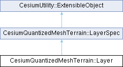
Inheritance diagram for CesiumQuantizedMeshTerrain::Layer:

Public Member Functions | |
| std::optional< CesiumGeospatial::Projection > | getProjection (const CesiumGeospatial::Ellipsoid &ellipsoid=CesiumGeospatial::Ellipsoid::WGS84) const noexcept |
| Gets the projection specified by this layer.json. | |
| std::optional< CesiumGeometry::QuadtreeTilingScheme > | getTilingScheme (const CesiumGeospatial::Ellipsoid &ellipsoid=CesiumGeospatial::Ellipsoid::WGS84) const noexcept |
| Gets the tiling scheme specified by this layer.json. | |
| std::optional< CesiumGeospatial::BoundingRegion > | getRootBoundingRegion (const CesiumGeospatial::Ellipsoid &ellipsoid=CesiumGeospatial::Ellipsoid::WGS84) const noexcept |
| Gets the bounding region for the root tile. | |
 Public Member Functions inherited from CesiumQuantizedMeshTerrain::LayerSpec Public Member Functions inherited from CesiumQuantizedMeshTerrain::LayerSpec | |
| int64_t | getSizeBytes () const |
| Calculates the size in bytes of this object, including the contents of all collections, pointers, and strings. This will NOT include the size of any extensions attached to the object. Calling this method may be slow as it requires traversing the object's entire structure. | |
 Public Member Functions inherited from CesiumUtility::ExtensibleObject Public Member Functions inherited from CesiumUtility::ExtensibleObject | |
| template<typename T> | |
| bool | hasExtension () const noexcept |
| Checks if an extension exists given its static type. | |
| template<typename T> | |
| const T * | getExtension () const noexcept |
| Gets an extension given its static type. | |
| template<typename T> | |
| T * | getExtension () noexcept |
| Gets an extension given its static type. | |
| const JsonValue * | getGenericExtension (const std::string &extensionName) const noexcept |
Gets a generic extension with the given name as a CesiumUtility::JsonValue. | |
| JsonValue * | getGenericExtension (const std::string &extensionName) noexcept |
Gets a generic extension with the given name as a CesiumUtility::JsonValue. | |
| template<typename T, typename... ConstructorArgumentTypes> | |
| T & | addExtension (ConstructorArgumentTypes &&... constructorArguments) |
| Adds a statically-typed extension to this object. | |
| template<typename T> | |
| void | removeExtension () |
| Removes a statically-typed extension from this object. | |
| int64_t | getSizeBytes () const |
| Calculates the size in bytes of this ExtensibleObject, including all of its extras but NOT including its extensions. Calling this method may be slow as it requires traversing the entire object. | |
Additional Inherited Members | |
 Public Attributes inherited from CesiumQuantizedMeshTerrain::LayerSpec Public Attributes inherited from CesiumQuantizedMeshTerrain::LayerSpec | |
| std::string | attribution |
| The attribution (credit) string for the terrain. | |
| std::vector< std::vector< CesiumQuantizedMeshTerrain::AvailabilityRectangle > > | available |
| The tile availability information. The outer array is indexed by tile level. The inner array is a list of rectangles of availability at that level. Tiles themselves may also contain further availability information for their subtree. | |
| std::vector< double > | bounds = {-180, -90, 180, 90} |
| The bounding box of the terrain, expressed as west, south, east, north in degrees. | |
| std::string | description |
| The description of this terrain tileset. | |
| std::vector< std::string > | extensionsProperty |
| The extensions available for this tileset. | |
| std::string | format = "quantized-mesh-1.0" |
The format of the terrain tiles. Should be "quantized-mesh-1.0". | |
| int64_t | maxzoom = int64_t() |
| The maximum level for which there are any available tiles. | |
| int64_t | minzoom = 0 |
| The minimum level for which there are any available tiles. | |
| std::optional< int64_t > | metadataAvailability |
| The levels at metadata is found in tiles. For example, if this value is 10, then metadata is found at levels 0, 10, 20, etc. | |
| std::string | name = "Terrain" |
| The name of this terrain tileset. | |
| std::optional< std::string > | parentUrl |
| The URL of the parent layer.json that this one is layered on top of. | |
| std::string | projection = "EPSG:4326" |
The map projection of this tileset. Valid values are "EPSG:4326" and "EPSG:3857". | |
| std::string | scheme = "tms" |
The tiling scheme. The only valid value is "tms". | |
| std::vector< std::string > | tiles |
| The URL templates from which to obtain tiles. | |
| std::string | version = "1.0.0" |
| The version of this tileset. | |
 Public Attributes inherited from CesiumUtility::ExtensibleObject Public Attributes inherited from CesiumUtility::ExtensibleObject | |
| std::unordered_map< std::string, std::any > | extensions |
| The extensions attached to this object. | |
| JsonValue::Object | extras |
| Application-specific data. | |
| JsonValue::Object | unknownProperties |
| Unknown properties that exist on this object but do not have any representation in the statically-typed classes. | |
 Static Public Attributes inherited from CesiumQuantizedMeshTerrain::LayerSpec Static Public Attributes inherited from CesiumQuantizedMeshTerrain::LayerSpec | |
| static constexpr const char * | TypeName = "Layer" |
| The original name of this type. | |
 Protected Member Functions inherited from CesiumQuantizedMeshTerrain::LayerSpec Protected Member Functions inherited from CesiumQuantizedMeshTerrain::LayerSpec | |
| LayerSpec ()=default | |
This class is not meant to be instantiated directly. Use Layer instead. | |
Detailed Description
Member Function Documentation
◆ getProjection()
|
noexcept |
Gets the projection specified by this layer.json.
- Returns
- The projection, or std::nullopt if this layer.json does not specify a valid projection.
◆ getRootBoundingRegion()
|
noexcept |
Gets the bounding region for the root tile.
The rectangle will be the maximum rectangle for the terrain's projection (geographic or web mercator). The heights will range from -1000.0 to 9000.0.
- Returns
- The bounding rectangle, or std::nullopt if the bounding region cannot be determined from this layer.json.
◆ getTilingScheme()
|
noexcept |
Gets the tiling scheme specified by this layer.json.
- Returns
- The tiling scheme, or std::nullopt if this layer.json does not specify a tiling scheme.
The documentation for this struct was generated from the following file:
- /home/runner/work/cesium-native/cesium-native/CesiumQuantizedMeshTerrain/include/CesiumQuantizedMeshTerrain/Layer.h