HNTB Streamlines Infrastructure Project Visualization with Cesium
When it comes to infrastructure investments, visualization transforms public engagement from abstract discussions to concrete decision-making. HNTB’s Immersive Media Solutions team uses Cesium ion, Cesium for Unreal, Cesium for Unity, and Google Photorealistic 3D Tiles to help community stakeholders better understand proposed infrastructure projects and engage meaningfully in the approval process.
A flythrough of a proposed design to replace the Bourne Bridge was used in public outreach efforts as part of the Cape Cod Bridges Program. Courtesy HNTB.
Founded in Kansas City, Missouri, in 1914, HNTB initially focused on designing railroad bridges. Today, the company offers comprehensive services in engineering, architecture, planning, and construction management, primarily focusing on transportation infrastructure. Their architectural services extend to designing and managing projects for public assembly facilities, including numerous prominent sports stadiums and arenas.
“When presenting an infrastructure project proposal for public engagement, it’s crucial that local stakeholders and property owners understand where their property, building, or favorite park is located in relation to the proposal, and that the surrounding context is recognizable,” HNTB immersive media solutions manager Dave Willard said.
Willard and his team create real-time interactive media to visualize and assess infrastructure project designs, from single highway interchanges to 30-mile road and rail corridors. They load a diverse range of 3D engineering and design models of roads, bridges, or rail networks—created in applications like OpenRoads, Revit, MicroStation, Civil3D, or SketchUp—directly into Unreal Engine or Unity. The team uses the Cesium for Unreal or Cesium for Unity plugins, depending on the project, and accesses Photorealistic 3D Tiles via Cesium ion to add real-world context, enriching project visualizations for public review and community engagement initiatives.
Designed to deliver highly detailed and realistic data for immersive environments, Google Maps Platform's Photorealistic 3D Tiles enable immersive experiences that scale from individual buildings to entire cities. Photorealistic 3D Tiles leverage the Open Geospatial Consortium (OGC) community standard 3D Tiles format, created by Cesium, which performantly streams massive amounts of 3D geospatial data.
Prior to adopting Cesium, providing accurate geospatial context for major projects was a significant time investment, requiring the team to manually model, texture, and detail existing buildings.
“Now, we bring that data in from Cesium and use it as-is in many cases,” Willard explained. “It removes the headache on our end, allowing us to focus our time on visualizing the proposed project instead of the buildings that are already there.”
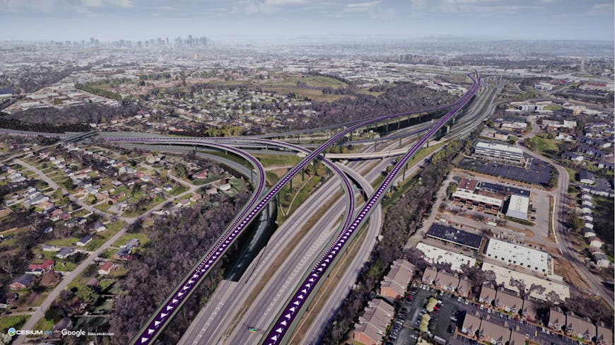
HNTB's visualization team extended Cesium's open-source platform to vertically align long linear infrastructure models with the Earth's curvature. Courtesy HNTB.
This capability proved invaluable to HNTB during its work on a long highway corridor project in the southeastern United States.
“Manually modeling existing buildings for contextual detail on long linear projects historically required over 1,000 hours of work,” Willard said. “Cesium reduces that time to between 200 and 300 hours."
The extensibility and open-source foundation of Cesium enabled HNTB's visualization team to build a tool that addressed the challenge they faced in accurately aligning this 26-mile corridor model. Traditional engineering designs don't account for the Earth's curvature, leading to noticeable vertical discrepancies over long distances—in this case, the model floated about 80 feet above the earth at one end and dipped 80 below the other.
HNTB developed a non-destructive mesh blending tool on top of Cesium that could automatically apply the necessary curvature to large, complex 3D models. This allowed them to continuously update design models in their Unity environment, with the tool automatically correcting for Earth's curvature, ensuring "ground truth accuracy" for their clients.
“One of the really cool things about having Cesium is the ability to build other tools on top of it,” remarked Adam Liss, HNTB senior immersive media specialist.
Willard's team, serving as a key consultant for the Massachusetts Department of Transportation on the Cape Cod Bridges Program, was tasked with presenting 10 different interchange configurations for public review.
Traditionally, this would have necessitated creating numerous individual videos and renderings for each combination, making it difficult for the public to compare scenarios and provide feedback. Instead, Willard's team applied their Cesium-powered interactive media capabilities, so presenters were able to dynamically display and toggle between these different interchange options, with detailed surroundings the reviewers expected to see, in real time via pixel streams and locally-run applications during public meetings.
HNTB’s team also built masking tools using Cesium. These tools enable them to overlay potential designs directly onto existing structures, making it easy for viewers to compare the past with the proposed future.
For a bridge proposal to link barrier islands along the Gulf Coast of Texas, HNTB integrated Cesium’s World Bathymetry data into their visualization. This addition helped stakeholders understand how underwater topography and the locations of historic shipwrecks impacted the busy shipping lanes beneath the proposed bridge design. “It’s important to be able to render this 2D-type information in a 3D context,” Liss explained.
This streamlined process, powered by Cesium, enables quick visualization of design alternatives and facilitates efficient collection of public input to identify preferred designs for their projects.
Innovation defines HNTB's 111-year legacy in infrastructure, a commitment clearly seen in their Immersive Media Solutions team's work to transform public engagement by making the abstract concrete. When it comes to Cesium, the team feels like they are just scratching the surface. “As we transition away from manual modeling of existing context, technologies like Cesium will continue to make our workflows much faster,” Willard said.
Looking into the future, Willard’s sights are set on digital twin delivery, bridging the work between owner-operators and engineering firms.
“The end goal isn't just about interactive real-time visualizations; it's transforming those visualizations into informational environments—digital twins,” Willard said. “Imagine delivering a complete football stadium or road corridor, complete with all its element-level metadata as a digital twin. That, to me, is a truly valuable deliverable for an engineering firm.”
Bring accurate real-world context, like Photorealistic 3D Tiles, to your infrastructure projects with Cesium ion.