日本工営 - Cesium for Unrealで描くインフラ革命
都市開発や社会インフラ整備において、関係者間の認識のズレは大きな課題でした。特に、専門知識のない行政担当者や住民にとって、設計意図を正確に理解することは容易ではありません。その背景には、膨大なデータをどのように統合し、可視化し、合意形成を円滑に進めるかという長年の問題がありました。特に、リアルな背景データの作成は、従来膨大な時間とコストを要する作業でした。しかし、日本工営株式会社はこの課題を解決するためにCesium for Unrealを導入し、設計対象エリアに対する正確な地理空間背景データの取得・処理を大幅に効率化。その結果、関係者や意思決定者、住民がインフラ設計やシミュレーションをより容易に理解できるようになりました。
背景と課題
都市開発やインフラ計画において、設計対象エリアのみならず、周辺環境の再現が不可欠です。背景データがなければ、設計の影響を適切に評価できず、関係者間の共通認識が形成されにくくなります。しかし、正確な地理空間の背景データの作成は従来、非常に手間のかかる作業であり、他にも多くの課題がありました。
- 背景データ作成の負担:都市全体や広範囲の地形データを個別に作成する必要があり、多大な時間と労力を要していた。
- データ統合の壁:DEMデータ、航空・衛星画像、点群データ、SfMメッシュ、BIM/CIMデータなど、多種多様なデータを手作業で統合する作業が必要だった。
- リアルタイムレンダリングの限界:高精細な3Dモデルの処理が困難で、スムーズなシミュレーションが実現できなかった。
こうした課題を克服するため、日本工営はCesium ionとCesium for Unrealを活用し、背景データの作成コストを劇的に削減しました。
Cesium ionとCesium for Unrealによる背景データの革新
高品質な3D地理空間データを活用した、効率的な背景データ生成
以前は、設計対象エリア外の背景モデルを作成するために、手作業で航空測量データや点群データを取得し、3Dモデリングソフトウェアで調整する必要がありました。しかし、Cesium ionを利用することで、このプロセスが一変しました。Cesium Globeの3Dコンテンツやパートナーのデータから地形・建物・画像情報にアクセスすることで、ゼロからデータセットを構築する必要をなくしたのです。
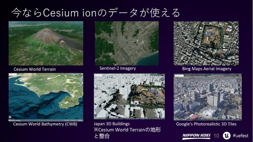
Unreal Fest 2024 Tokyo 講演資料より抜粋 提供:日本工営株式会社
- Cesium World Bathymetry を活用し、海底地形データをそのまま取り込むことで、港湾・沿岸開発の背景作成が簡単に。
- Google Photorealistic 3D Tiles を適用することで、高精度な都市環境を手作業なしで背景データとして取得。
- Bing Mapsの航空写真 + Cesium World Terrain を活用し、広範囲の地形情報を即座に統合。
- Japan 3D Buildings は、国土交通省PLATEAUが提供する全国200を超える市区町村において、クリック一つでこれまで整備されたすべての建物データが利用可能。
- Cesium ionのContent Data(衛星画像、3D建築データ、地形情報など)を利用することで、ゼロからデータを作成する手間を省き、高品質な背景データを短時間で取得可能。
これにより、日本工営では、背景データ作成にかかっていた膨大な工数を削減し、設計エリアのモデリングに集中できるようになりました。
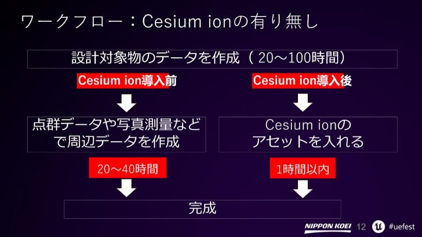
Cesium ion導入による作業工数削減効果 - Unreal Fest 2024 Tokyo 講演資料より抜粋。提供:日本工営株式会社
Cesium ionを通じたUnreal Engineとのシームレスな統合
Cesium ionとCesium for Unreal pluginを活用することで、膨大な地理空間データをクラウドから直接ストリーミングし、Unreal Engine内でダイナミックに可視化が可能になりました。
- 3Dタイルの自動処理:Cesium ionのタイリングパイプラインを活用し、BIM/CIMデータを自動的に3Dタイル化。
- リアルタイムストリーミング:Google Photorealistic 3D TilesやCesium World Terrain、測量で取得した地形のデータを動的に読み込み、必要に応じて表示。
- データの軽量化とパフォーマンス向上:Cesium ion上で処理されたデータをCesium for Unrealを使用しUnreal Engineに取り込み、最適化された形でレンダリング。
事例
水辺空間開発プロジェクト
住民説明会では、Cesium World TerrainやCesium ionに搭載されているPLATEA 3D都市モデルを活用し、設計対象箇所に密接に関連する都市の背景データを即座に表示。住民が自分の街の未来像を直感的に理解でき、説明の効率が向上しました。従来の住民説明会では、パースや平面配置図を使用しており、参加者が自ら頭の中で3次元空間を想像していましたが、この手法により、空間に対する正確な共通認識を得た状態で議論を行うことができました。
水辺空間開発プロジェクトでの活用例 提供:日本工営株式会社
河川、流域管理プロジェクト
Bing画像 + Cesium World Terrainを利用し、川の周辺環境を詳細に再現。流況シミュレーションデータと組み合わせることで、河川の状態や氾濫リスクの可視化が飛躍的に向上しました。河川の流れの様子や都市の氾濫シミュレーションをCesiumの各種データと重ね合わせることで、場所に対する理解、リスクの理解が大幅に向上します。流況シミュレーションをゲームエンジンで表現する取り組みは進めていましたが、場所の理解につながる周辺環境の際現には時間がかかっていました。これがCesium ionとCesium for Unrealを用いることで大幅に効率化できるようになりました。
河川管理プロジェクトの成果例 出典:日本工営株式会社
地震データの可視化
Cesium World Bathymetryを活用し、震源データを海底地形と統合。日本工営は、これにより、震源位置や震源域の変化、海底地形との関係性など防災や地球科学の観点で有用な可視化を実現しました。非常に多くの地震が日本全国で発生していることを立体的に見ることは、防災教育の観点でも重要な資料として利用できると考えられます。
2020年~2022年3月までの震源位置を3Dデータの動画で見せたもの(提供:日本工営株式会社)
上の動画のコンテンツを制作した日本工営の佐藤隆洋氏は、以下のように語ります。「日本ではプレート沿いや断層沿いに発生する地震が多く、震源位置を3次元で表現した見せ方でも、関連性が浮かび上がってきます。そこで2020年~2022年3月までの震源位置を3Dデータの動画で見れるように作成したのが上の動画コンテンツです。
一方で、プレート活動により発生する地震とプレート活動で形成された海底地形の関係性の理解まではできません。そこで、Cesium ionとCesium for Unreal、およびCesium ionのworld Bathymetryを使用して、震源の位置と海底地形の関係や、地震の発生状況を時系列で表現する取り組みを行いました。それが、2024年8月に日向灘で起きた地震を可視化した次のコンテンツになります。この地震では南海トラフ地震臨時情報(巨大地震注意)が発表されています。このコンテンツでは、地震の発生場所はどこか、発生場所は移動しているのかなど、海底地形と同時に表示することで現象の理解を深めることができたと考えています。」
(2024年8月8日の日向灘の地震:8月8日に日向灘を震源とするM7.1,最大震度6弱の地震が発生。このコンテンツは、その地震をUnrealEngineとCesium ionを活用して可視化し、震源の位置と海底地形の関係や、地震の発生状況を時系列で表現したもの。Cesium World Bathymetryを利用。 動画提供:日本工営株式会社、 2024年8月6日~17日の震源データ出典:気象庁震源リスト)
地震の震源データ可視化プロジェクトの成果例 提供:日本工営株式会社
土砂災害シミュレーション
土砂災害は、大雨や地震などにより発生し大きな被害を生じさせます。どういったメカニズムで土砂災害が発生しているのかの理解は、対策を考えるうえでも重要になります。そしてここでも、土砂災害が発生している場所と周辺の関係性の理解が重要になります。Cesium for UnrealとCesium ionに登録した詳細な地形データやCesium World Terrainを活用し、高精度な地形データを取得。土砂崩れの3次元シミュレーションと合成することで、どういった現象がどこで発生したのかの理解が容易になっています。
土砂災害シミュレーション可視化の成果例 提供:日本工営株式会社
Cesium ionの活用により、日本工営は以下の大きなメリットを得ました。
- 各種データの重ね合わせの効率化:Cesium ionを利用することで詳細な測量データや各種モデルの地理的座標合わせの効率化が図られました。
- 背景モデル作成の時間削減:従来の手作業による背景作成が不要になり、設計業務に注力できるようになりました。
- プロジェクトのスピード向上:背景作成がゼロになったことで、設計や解析により集中できるようになりました。
- 合意形成の迅速化:高精度な背景データを即座に表示できるため、関係者全員が直感的に理解できるようになりました。
今後の展望
日本工営は、Cesium for Unreal、Cesium ionの活用をさらに拡大し、スマートシティやデジタルツインの導入を推進。今後は、ゲーミフィケーションの要素を取り入れ、市民参加型の都市計画やインフラ管理を実現していく予定です。
高品質な3D地理空間データで変わる未来のインフラ設計
Cesium ionとCesium for Unrealの活用により、日本工営は、インフラ設計の大幅な効率化と高精度な可視化とシミュレーションを実現しました都市開発や社会インフラ整備の分野において、より正確でリアルな3D空間を提供し、リソースを最適に活用するために、ぜひCesium ionアカウントに登録してください。
Introduction
In urban development and social infrastructure projects, discrepancies in understanding among stakeholders have long been a significant challenge. For government officials and residents without specialized knowledge, accurately grasping the intent behind a design is not always straightforward. At the heart of this challenge lies the need to effectively integrate vast amounts of data, visualize it clearly, and facilitate smooth consensus-building.
Particularly, creating realistic background data has traditionally been a labor-intensive and costly process. To address this, Nippon Koei began using Cesium ion and Cesium for Unreal, significantly streamlining the acquisition and processing of accurate geospatial context for a design area. As a result, collaborating stakeholders, decision-makers, and residents are more easily able to comprehend infrastructure designs and simulations.
Background and challenges
Recreating not only the design area but also its surrounding environment is crucial in urban development and infrastructure planning. Without accurate background data, it becomes difficult to properly assess the impact of a design, making it harder for stakeholders to establish a common understanding. Creating this accurate geospatial context has traditionally been a time-consuming and labor-intensive process, accompanied by several key challenges:
- The burden of background data creation: Large-scale terrain and city models had to be manually created, requiring extensive time and effort.
- Challenges in data integration: Combining multiple data formats—such as DEM, aerial and satellite imagery, point cloud data, SfM meshes, and BIM/CIM data—often required manual adjustments.
- Limitations in real-time rendering: Processing high-resolution 3D models was computationally demanding, making smooth simulation and real-time visualization difficult.
To overcome these challenges, Nippon Koei adopted Cesium ion and Cesium for Unreal, significantly reducing the cost and time required for background data creation.
Revolutionizing background data with Cesium ion and Cesium for Unreal
Leveraging curated 3D content for seamless background data generation
Previously, creating models for areas surrounding the core design zone required manually acquiring aerial survey data, processing point cloud data, and refining models using 3D modeling software. Nippon Koei uses Cesium ion to access terrain, buildings, and imagery from Cesium Globe 3D Content and partner data, eliminating the need to build datasets from scratch.
Datasets available via Cesium ion. Excerpt from presentation materials at Unreal Fest 2024 Tokyo. (Courtesy of Nippon Koei Co., Ltd.)
- Cesium World Bathymetry enables direct integration of seabed terrain data, simplifying background creation for port and coastal development projects.
- Google Photorealistic 3D Tiles provide detailed urban environments, eliminating the need for manual modeling of background data.
- Bing Maps Aerial imagery + Cesium World Terrain allows for instant integration of large-scale terrain information.
- Japan 3D Buildings allows users to access building data with one click from over 200 municipalities nationwide from PLATEAU (provided by the Ministry of Land, Infrastructure, Transport and Tourism).
With Cesium ion, Nippon Koei has drastically reduced the labor previously required for surrounding geospatial data creation, allowing engineers to focus on modeling the actual design area.
Impact of Cesium ion on reducing workload. What used to take 20-40 hours now takes just 1 with Cesium. Excerpt from presentation materials at Unreal Fest 2024 Tokyo. (Courtesy of Nippon Koei Co., Ltd.)
Seamless integration with Unreal Engine
With Cesium ion and the Cesium for Unreal plugin, vast amounts of geospatial data can be streamed directly from the cloud, enabling dynamic visualization in Unreal Engine with high efficiency.
- Automated 3D tiling: The Cesium ion tiling pipeline allows BIM/CIM data to be converted into 3D Tiles without manual intervention.
- Real-time streaming: Google Photorealistic 3D Tiles, Cesium World Terrain, and survey-based terrain datasets can be dynamically loaded and displayed as needed.
Optimized performance: Cesium ion processes data efficiently, allowing seamless integration and rendering of optimized data within Unreal Engine.
Real-world applications
Waterfront development project
During a public consultation meeting, Cesium World Terrain and PLATEAU 3D city models available on Cesium ion were used to instantly visualize urban background data closely related to the design area. Residents were able to intuitively grasp the future vision of their city, significantly improving communication and efficiency in the presentation.
Previously, such meetings relied on static perspective drawings and site plans, requiring attendees to mentally reconstruct 3D spaces. However, with this new approach, discussions took place with a shared and accurate spatial understanding, eliminating interpretation gaps and improving decision-making processes.
Using Cesium in waterfront development projects. Courtesy Nippon Koei Co., Ltd.
River management project
Nippon Koei used Bing Maps Aerial imagery and Cesium World Terrain and have achieved a highly detailed reproduction of the river’s surrounding environment. When combined with flow simulation data, the visualization of river conditions and flood risks has improved dramatically. Overlaying river flow patterns and urban flood simulations with various Cesium datasets significantly enhances spatial understanding and risk awareness. While they had been working on visualizing flow simulations using game engines, reproducing the surrounding environment to support spatial understanding used to be time-consuming. This process has now been greatly streamlined through the use of Cesium ion and Cesium for Unreal.
Using Cesium for river management project outcomes. Courtesy Nippon Koei Co., Ltd.
Earthquake data visualization
3D visualization content of the earthquake epicenter. Courtesy Nippon Koei Co., Ltd.
This video content visualizes the hypocenter locations of earthquakes that occurred between 2020 and March 2022 using 3D data. In Japan, many earthquakes occur along tectonic plate boundaries and fault lines, and by presenting the hypocenters in three dimensions, these correlations become more apparent. However, this method alone does not provide a clear understanding of the relationship between earthquakes caused by plate activity and the seafloor topography shaped by that same activity.
To address this, Nippon Koei used Cesium for Unreal, Cesium ion, and Cesium World Bathymetry to visualize the relationship between hypocenter locations and seafloor features, as well as to show the progression of seismic activity over time. This led to the creation of new content visualizing the earthquake that occurred off the coast of Hyuga-nada in August 2024. In this case, an Emergency Nankai Trough Earthquake Information (warning of a potential megathrust earthquake) was issued.
By displaying the location and movement of the earthquake in conjunction with the seafloor topography, this content helped deepen understanding of the phenomena.
A 3D visualization powered by Cesium, illustrating the August 8, 2024 Hyūga-nada earthquake’s epicenter, seabed topography, and seismic timeline. Courtesy Nippon Koei Co., Ltd.
On August 8, 2024, a magnitude 7.1 earthquake struck the Hyūga-nada Sea, registering a maximum seismic intensity of lower 6 on the Japanese scale. This content illustrates the relationship between the earthquake's epicenter and the seabed topography, as well as the chronological progression of the seismic events. Nippon Koei used Cesium World Bathymetry for geospatial context. Seismic data source: Japan Meteorological Agency earthquake list from August 6-17, 2024.
Landslide simulation
Landslides can occur due to heavy rain, earthquakes, and other natural events, often resulting in significant damage. Understanding the mechanisms behind how landslides occur is essential when considering effective countermeasures. In addition, it is crucial to understand the relationship between the locations where landslides occur and their surrounding environments.
Using Cesium for Unreal along with high-resolution terrain data uploaded to Cesium ion, the Nippon Koei team generated a high-fidelity mountain landscape to support 3D landslide simulations.
By integrating real-world elevation data and erosion models, researchers and engineers can better understand how landslides develop and are able to predict potential high-risk areas.
Visualization results from landslide disaster simulation. Courtesy Nippon Koei Co., Ltd.
By adopting Cesium ion, Nippon Koei now has:
- Efficient data integration: Cesium ion streamlined the alignment of survey datasets and 3D models with accurate geospatial positioning.
- Reduced background model creation time: Manual background creation was eliminated, allowing greater focus on core design and analysis tasks.
- Accelerated project timelines: With accurate geospatial context readily available, engineers and planners are able to work more efficiently.
- Faster consensus building: High-precision models of surrounding areas allow all stakeholders to immediately grasp key project aspects, leading to more effective discussions and approvals.
Outlook
Nippon Koei plans to further expand its use of Cesium for Unreal and Cesium ion, driving advancements in smart city development and digital twin technology.
By incorporating elements of gamification, the company aims to promote more interactive, community-driven urban planning and infrastructure management.
Transforming infrastructure design with curate 3D content
By utilizing Cesium ion and Cesium for Unreal, Nippon Koei has significantly improved the efficiency of infrastructure design, enhancing both visualization and simulation capabilities for its users.
To provide more accurate and realistic 3D spaces and optimize resources in urban development and social infrastructure maintenance, sign up for a Cesium ion account.