OrbPro Calculates Orbits and Validates Imagery Collection with CesiumJS and Photorealistic 3D Tiles
OrbPro enables space operators to visualize objects in orbit around Earth and validate locations to be imaged on Earth with CesiumJS and Google Maps Platform’s Photorealistic 3D Tiles.
Advanced camera control enables OrbPro users to view accurate global terrain from hundreds of miles above Earth and at city scale. Courtesy DigitalArsenal.
Built for space app developers by Cesium Certified Developer DigitalArsenal, OrbPro is a web-based library combining orbital propagators, a sensors engine, and line-of-sight calculations, with the ability to display 100,000 space objects orbiting our planet and assess their capabilities. Civil, military, and commercial space operators visualize their own satellites and others to calculate pass schedules, ensuring broadcast and internet connectivity or coordinating imagery collection.
DigitalArsenal's OrbPro combines orbital propagators, a sensors engine, and line-of-sight calculations. Try it yourself here and at https://SpaceAware.io. Courtesy DigitalArsenal.
OrbPro's in-browser database for satellite catalog information allows for efficient client-side queries; it eliminates the need for server-side data processing and results in faster, more responsive data retrieval. In addition to serving as a visualization library, OrbPro provides dynamic line-of-sight computations between any two entities within its database, so users can determine visual or communication interferences, assess potential obstructions, and understand relational dynamics in real time.
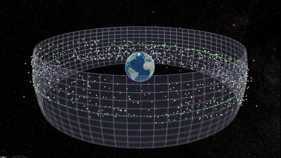
Modeling a large constellation with similar sensors and coverage areas. Courtesy DigitalArsenal.
OrbPro incorporates data from Celestrak, Space-Track, and users themselves to accurately plot, identify, and filter space objects. This info is formatted as Consultative Committee for Space Data Systems (CCSDS)–compliant messages, to ensure consistency across data transmitted and received.
Advanced camera control enables OrbPro users to view accurate global terrain from hundreds of miles above Earth and at city scale. OrbPro accesses Cesium World Terrain and Bing Maps Aerial imagery from Cesium ion and integrates Photorealistic 3D Tiles via Google Maps Platform’s Map Tiles API. These ground-view datasets are tiled as 3D Tiles and streamed into CesiumJS to provide the interactive geospatial context that confirms specific coverage for space operators.
SAR sensor field of regard. Courtesy DigitalArsenal.
OrbPro was specially designed to run on low-power thin clients and disadvantaged networks, supporting access in SCIFs or even in the field. Because there are no International Traffic in Arms Regulations (ITAR) components to the library, public- and private-sector users access the same platform.
Geostationary satellites and the geoprotection zone visualized as a geometry. Courtesy DigitalArsenal.
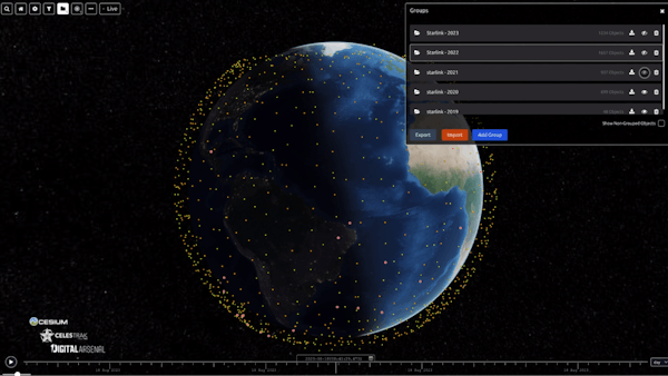
Custom satellite catalog query with visualization. Courtesy DigitalArsenal.
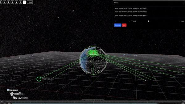
Calculating access to communications satellites. Courtesy DigitalArsenal.
"CesiumJS is truly cross-platform. It runs on every device and operating system that can run a browser, and even headless on those that can't. This makes it an extremely versatile option that can be used in a wide range of applications. Another advantage: it comes with everything you need right out of the box. From glTF models to the latest in 3D Tiles, reading all major geospatial serialization formats, imagery and terrain, there's very little you can find that Cesium doesn't support," said TJ Koury, CEO of DigitalArsenal.
DigitalArsenal has contributed to open-source CesiumJS for years and plans to formally release OrbPro in the first half of 2024.
You can learn to load Photorealistic 3D Tiles into your CesiumJS app by following our tutorials.