IMS Monitoring Networks at Remote Mines with Cesium
Mines are increasingly incorporating smart equipment into their operations, with sensors and feedback to keep the entire system running. But because mines are often in remote locations, they can struggle with connectivity issues. Those issues can be costly: if a single autonomous truck loses connection to the network, all the nearby vehicles have to shut down to avoid collisions.
That’s where FTP Solutions comes in. Their Integrated Management System (IMS) monitors the network connection of all devices onsite so if a vehicle loses connection to the network, engineers can quickly diagnose the problem and get the whole site moving again.
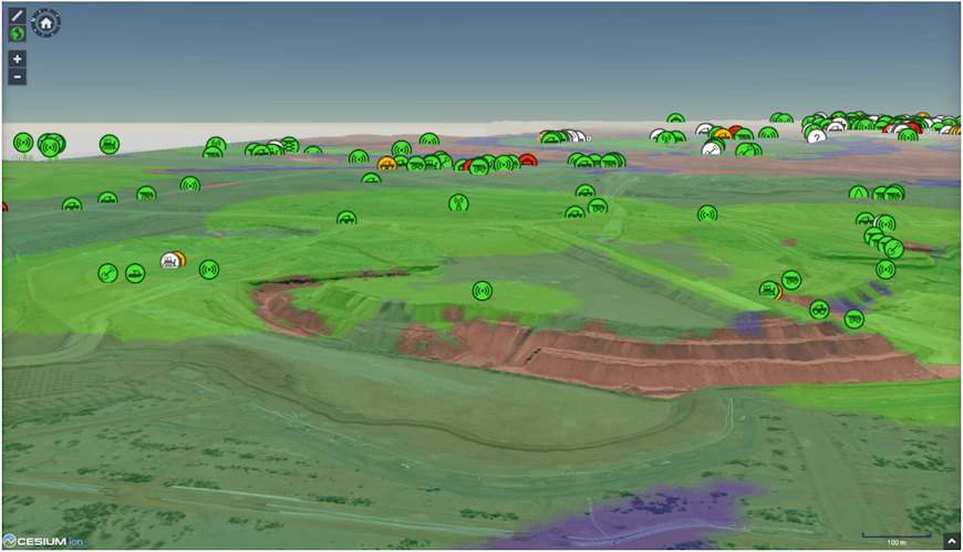
With IMS, engineers remotely detect the signal strength of networks, track asset connectivity, and verify RF coverage, latency, and availability across the site.
FTP Solutions is a long-time user of CesiumJS. They first began using Cesium at the 1.06 release in 2015. At the time they had built a monitoring software on Google Maps, but Cesium’s time dynamic capabilities were critical to their use case so they migrated to CesiumJS.
Their application has since grown from a system for monitoring and planning effective wireless networks on mine sites to a platform that takes in data from dozens of different systems and streams it to an accessible frontend that uses Cesium for contextual awareness. Their visualization component shows all sorts of assets on a mine site—from autonomous haulage trucks, diggers, and drills to solar panels, generators, and water pumps—and displays their location and data on a highly detailed map of the terrain, in real time.
IMS users can view networks in real time or review the site's history to better understand any issues.
With IMS, engineers at the mine can both monitor assets and network infrastructure in real-time, and also go back in time and diagnose issues impacting a site. Diagnosing where connectivity issues originated can be very complex, but being able to see the exact moment the connection stopped and where the breakdown occurred dramatically simplifies that analysis.
To visualize your own geographic data, sign up for a Cesium ion account.
IMS uses shows the real-time location of assets at the site using their GPS data, including heavy machinery, trucks, and personnel. Users can also set up geofences to define restricted and secured zones, and to create location-based triggers and alerts.