Cesium and Kaarta Visualizing Indoor and Underground Environments with High Resolution LiDAR
Cesium is making it easier for first responders and military operators to quickly assess and understand the dense—and changing—urban environments in which they perform much of their work.
Cesium supports visualization at any scale, from global to sub-centimeter. And with our recent improved support for subsurface visualization, exploring underground environments is intuitive and seamlessly integrated with aboveground data.
We recently put these capabilities to the test for the Dense Urban Online Challenge, organized by the National Security Innovation Network (NSIN), a DoD program, to solve the problems that first responders and military operators have when working in cities with high density and complex underground structures.
For the challenge we collaborated with Kaarta to show how Cesium can power a myriad of applications to solve these operational issues by bringing together all the data and visualizing it in a way to give decision makers the information and insight they need.
A portion of the East Side Access tunnel in New York City, captured by Kaarta.
For the hackathon we showed New York City tunnels, collected by Kaarta’s mobile 3D scanners. These point clouds were captured using their hand-held device, with laser accuracy within 3 cm—just by walking through the tunnel with the device. The point cloud it generated was tiled and geolocated with Cesium ion.
The value here is that you can quickly capture these accurate 3D scans, and do so frequently, so you can have a map that’s always up to date, even for projects that are actively being developed like New York City’s East Side Access tunnel. For first responders and military operators, an up to date map of these dense environments is crucial for making decisions.
As devices like these make near real time high resolution scans possible, with Cesium you can combine these scans to see how all projects in any given area are developing at the same time. By combining with other datasets, it is easy to plan for potential conflicts, for example, by overlaying a map of the sewer system to make sure it’s not getting too close. With Cesium’s measurement tools, these analyses are simple and integrated.
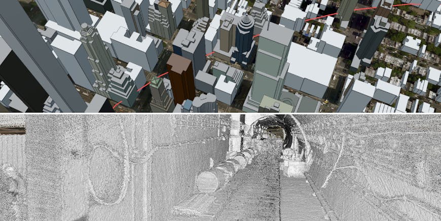
Top: above ground view of New York City with the tunnel’s location marked in red. Bottom: interior view of the tunnel.
Of the 31 teams that participated in the NSIN Dense Urban Online Challenge, we were one of 5 selected to join an in-person hackathon. We’re excited to provide the platform that enables others to solve these complex challenges. If you’re doing underground work, or you’re interested in Cesium for defense, reach out to me at brady@cesium.com.