EdgyGeo Gives Realtors an Edge with Cesium
Anyone who’s browsed Zillow or City-Data has seen that open data is dramatically reshaping the real estate industry. EdgyGeo takes this data access to a whole new level with tools to better manage buildings at all stages of development, from architects visualizing new spaces to agents offering commercial real estate to governments maintaining smart cities. With Cesium, they’re able to bring vast amounts of data together into a single platform for better decision making.

High resolution 3D buildings combined with Cesium World Terrain in EdgyGeo’s app.
Millions of 3D buildings, in the browser
EdgyGeo was created as a collaboration between NextSpace and CyberCity 3D. The heart of EdgyGeo’s platform is building data from CyberCity’s 3D city datasets, which include more than 1.5 million high resolution building models in more than 125 cities worldwide. Each building model is complete with metadata and measurements accurate up to 6 inches. EdgyGeo uses Cesium’s 3D Tiling pipelines to optimize this data for streaming so users can quickly navigate entire cities of 3D building models, visualized in Cesium.

3D rendering in EdgyGeo’s suite presentation mode, used for leasing, sales, and tenant advisory services.
With Cesium ion, EdgyGeo fuses their 3D buildings with satellite imagery, terrain, and vector data, as well as their customers’ data. Edgygeo offers custom solutions—all built on Cesium—for real estate managers, architects, city governments, and investors, who use EdgyGeo for property analysis, investment data, and neighborhood insights.
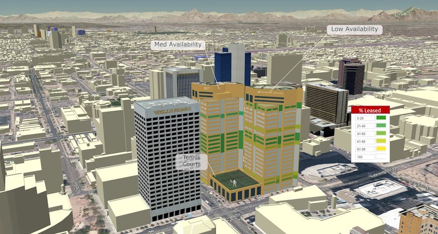
EdgyGeo merges rich data sources with high end visualization for effective presentations. Here buildings from CyberCity 3D’s database, Trimble, and Sketchup are labeled and styled to quickly share relevant data.
Smarter shopping with a commercial real estate SaaS
Take a realtor helping a company find new office space. Within EdgyGeo’s browser app, built on Cesium, the agent can show a 3D city with available spaces, highlighted by listing agent or other metrics. With integrated street views, map views, and 3D building views, the app can provide a real sense of the space.
Users can see available spaces in multi story buildings and can navigate to the buildings to view accurate shadows throughout the day or see the view from any floor. They can check traffic data, bikeways, census data, light rail options, community centers, and parks, all integrated into a single view. And they can use this semantic data to color code available properties, making it possible to quickly visually assess the options.
If you’re looking to efficiently share multiple 3D datasets, start uploading your own data today bysigning upfor a free ion community account.