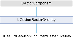
 |
Cesium for Unreal 2.23.0
|
 |
Cesium for Unreal 2.23.0
|
#include <CesiumGeoJsonDocumentRasterOverlay.h>

Public Attributes | |
| ECesiumGeoJsonDocumentRasterOverlaySource | Source |
| int64 | IonAssetID |
| The ID of the Cesium ion asset to use. | |
| UCesiumIonServer * | CesiumIonServer |
| The Cesium ion Server from which this raster overlay is loaded. | |
| FCesiumGeoJsonDocument | GeoJsonDocument |
| A FCesiumGeoJsonDocument to display. | |
| FString | Url |
| A URL to load a GeoJSON document from. | |
| TMap< FString, FString > | RequestHeaders |
Headers to use while making a request to Url to load a GeoJSON document. | |
| int32 | MipLevels = 0 |
| The number of mip levels to generate for each tile of this raster overlay. | |
| FCesiumVectorStyle | DefaultStyle |
| The default style to use for this raster overlay. | |
| FCesiumGeoJsonDocumentRasterOverlayOnDocumentLoadedCallback | OnDocumentLoaded |
| A callback that will be called when the document has been loaded. | |
 Public Attributes inherited from UCesiumRasterOverlay Public Attributes inherited from UCesiumRasterOverlay | |
| FString | MaterialLayerKey = "Overlay0" |
| The key to use to match this overlay to a material layer. | |
| FRasterOverlayRendererOptions | rendererOptions |
| Sets the texture filter and texture group of raster tile images. | |
Protected Member Functions | |
| virtual std::unique_ptr< CesiumRasterOverlays::RasterOverlay > | CreateOverlay (const CesiumRasterOverlays::RasterOverlayOptions &options={}) override |
 Protected Member Functions inherited from UCesiumRasterOverlay Protected Member Functions inherited from UCesiumRasterOverlay | |
| Cesium3DTilesSelection::Tileset * | FindTileset () const |
| virtual void | OnAdd (Cesium3DTilesSelection::Tileset *pTileset, CesiumRasterOverlays::RasterOverlay *pOverlay) |
| virtual void | OnRemove (Cesium3DTilesSelection::Tileset *pTileset, CesiumRasterOverlays::RasterOverlay *pOverlay) |
Additional Inherited Members | |
 Public Member Functions inherited from UCesiumRasterOverlay Public Member Functions inherited from UCesiumRasterOverlay | |
| UCesiumRasterOverlay () | |
| void | AddToTileset () |
| Displays this raster overlay on its owning Cesium 3D Tileset Actor, without changing its activation state. | |
| void | RemoveFromTileset () |
| Stops displaying this raster overlay on its owning Cesium 3D Tileset Actor. | |
| void | Refresh () |
| Refreshes this overlay by removing from its owning Cesium 3D Tileset Actor and re-adding it. | |
| double | GetMaximumScreenSpaceError () const |
| void | SetMaximumScreenSpaceError (double Value) |
| int32 | GetMaximumTextureSize () const |
| void | SetMaximumTextureSize (int32 Value) |
| int32 | GetMaximumSimultaneousTileLoads () const |
| void | SetMaximumSimultaneousTileLoads (int32 Value) |
| int64 | GetSubTileCacheBytes () const |
| void | SetSubTileCacheBytes (int64 Value) |
| virtual void | Activate (bool bReset) override |
| Activates this raster overlay, which will display it on the Cesium3DTileset to which the component is attached, if it isn't already displayed. | |
| virtual void | Deactivate () override |
| Deactivates this raster overlay. | |
| virtual void | OnComponentDestroyed (bool bDestroyingHierarchy) override |
| virtual bool | IsReadyForFinishDestroy () override |
 Protected Attributes inherited from UCesiumRasterOverlay Protected Attributes inherited from UCesiumRasterOverlay | |
| double | MaximumScreenSpaceError = 2.0 |
| The maximum number of pixels of error when rendering this overlay. | |
| int32 | MaximumTextureSize = 2048 |
| The maximum texel size of raster overlay textures, in either direction. | |
| int32 | MaximumSimultaneousTileLoads = 20 |
| The maximum number of overlay tiles that may simultaneously be in the process of loading. | |
| int64 | SubTileCacheBytes = 16 * 1024 * 1024 |
| The maximum number of bytes to use to cache sub-tiles in memory. | |
| bool | ShowCreditsOnScreen |
| Whether or not to show credits of this raster overlay on screen. | |
Definition at line 44 of file CesiumGeoJsonDocumentRasterOverlay.h.
|
overrideprotectedvirtual |
Reimplemented from UCesiumRasterOverlay.
| UCesiumIonServer* UCesiumGeoJsonDocumentRasterOverlay::CesiumIonServer |
The Cesium ion Server from which this raster overlay is loaded.
Definition at line 76 of file CesiumGeoJsonDocumentRasterOverlay.h.
| FCesiumVectorStyle UCesiumGeoJsonDocumentRasterOverlay::DefaultStyle |
The default style to use for this raster overlay.
If no style is set on a GeoJSON object or any of its parents, this style will be used instead.
Definition at line 135 of file CesiumGeoJsonDocumentRasterOverlay.h.
| FCesiumGeoJsonDocument UCesiumGeoJsonDocumentRasterOverlay::GeoJsonDocument |
A FCesiumGeoJsonDocument to display.
Definition at line 88 of file CesiumGeoJsonDocumentRasterOverlay.h.
| int64 UCesiumGeoJsonDocumentRasterOverlay::IonAssetID |
The ID of the Cesium ion asset to use.
Definition at line 63 of file CesiumGeoJsonDocumentRasterOverlay.h.
| int32 UCesiumGeoJsonDocumentRasterOverlay::MipLevels = 0 |
The number of mip levels to generate for each tile of this raster overlay.
Additional mip levels can improve the visual quality of tiles farther from the camera at the cost of additional rasterization time to create each mip level.
Definition at line 126 of file CesiumGeoJsonDocumentRasterOverlay.h.
| FCesiumGeoJsonDocumentRasterOverlayOnDocumentLoadedCallback UCesiumGeoJsonDocumentRasterOverlay::OnDocumentLoaded |
A callback that will be called when the document has been loaded.
Definition at line 141 of file CesiumGeoJsonDocumentRasterOverlay.h.
| TMap<FString, FString> UCesiumGeoJsonDocumentRasterOverlay::RequestHeaders |
Headers to use while making a request to Url to load a GeoJSON document.
Definition at line 112 of file CesiumGeoJsonDocumentRasterOverlay.h.
| ECesiumGeoJsonDocumentRasterOverlaySource UCesiumGeoJsonDocumentRasterOverlay::Source |
Definition at line 50 of file CesiumGeoJsonDocumentRasterOverlay.h.
| FString UCesiumGeoJsonDocumentRasterOverlay::Url |
A URL to load a GeoJSON document from.
Definition at line 100 of file CesiumGeoJsonDocumentRasterOverlay.h.