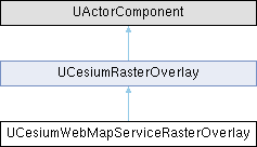
 |
Cesium for Unreal 2.22.1
|
 |
Cesium for Unreal 2.22.1
|
A raster overlay that directly accesses a Web Map Service (WMS) server. More...
#include <CesiumWebMapServiceRasterOverlay.h>

Public Attributes | |
| FString | BaseUrl |
| The base url of the Web Map Service (WMS). | |
| FString | Layers |
| Comma-separated layer names to request from the server. | |
| int32 | TileWidth = 256 |
| Image width. | |
| int32 | TileHeight = 256 |
| Image height. | |
| int32 | MinimumLevel = 0 |
| Minimum zoom level. | |
| int32 | MaximumLevel = 14 |
| Maximum zoom level. | |
| TMap< FString, FString > | RequestHeaders |
| HTTP headers to be attached to each request made for this raster overlay. | |
 Public Attributes inherited from UCesiumRasterOverlay Public Attributes inherited from UCesiumRasterOverlay | |
| FString | MaterialLayerKey = "Overlay0" |
| The key to use to match this overlay to a material layer. | |
| FRasterOverlayRendererOptions | rendererOptions |
| Sets the texture filter and texture group of raster tile images. | |
Protected Member Functions | |
| virtual std::unique_ptr< CesiumRasterOverlays::RasterOverlay > | CreateOverlay (const CesiumRasterOverlays::RasterOverlayOptions &options={}) override |
 Protected Member Functions inherited from UCesiumRasterOverlay Protected Member Functions inherited from UCesiumRasterOverlay | |
| Cesium3DTilesSelection::Tileset * | FindTileset () const |
| virtual void | OnAdd (Cesium3DTilesSelection::Tileset *pTileset, CesiumRasterOverlays::RasterOverlay *pOverlay) |
| virtual void | OnRemove (Cesium3DTilesSelection::Tileset *pTileset, CesiumRasterOverlays::RasterOverlay *pOverlay) |
Additional Inherited Members | |
 Public Member Functions inherited from UCesiumRasterOverlay Public Member Functions inherited from UCesiumRasterOverlay | |
| UCesiumRasterOverlay () | |
| void | AddToTileset () |
| Displays this raster overlay on its owning Cesium 3D Tileset Actor, without changing its activation state. | |
| void | RemoveFromTileset () |
| Stops displaying this raster overlay on its owning Cesium 3D Tileset Actor. | |
| void | Refresh () |
| Refreshes this overlay by removing from its owning Cesium 3D Tileset Actor and re-adding it. | |
| double | GetMaximumScreenSpaceError () const |
| void | SetMaximumScreenSpaceError (double Value) |
| int32 | GetMaximumTextureSize () const |
| void | SetMaximumTextureSize (int32 Value) |
| int32 | GetMaximumSimultaneousTileLoads () const |
| void | SetMaximumSimultaneousTileLoads (int32 Value) |
| int64 | GetSubTileCacheBytes () const |
| void | SetSubTileCacheBytes (int64 Value) |
| virtual void | Activate (bool bReset) override |
| Activates this raster overlay, which will display it on the Cesium3DTileset to which the component is attached, if it isn't already displayed. | |
| virtual void | Deactivate () override |
| Deactivates this raster overlay. | |
| virtual void | OnComponentDestroyed (bool bDestroyingHierarchy) override |
| virtual bool | IsReadyForFinishDestroy () override |
 Protected Attributes inherited from UCesiumRasterOverlay Protected Attributes inherited from UCesiumRasterOverlay | |
| double | MaximumScreenSpaceError = 2.0 |
| The maximum number of pixels of error when rendering this overlay. | |
| int32 | MaximumTextureSize = 2048 |
| The maximum texel size of raster overlay textures, in either direction. | |
| int32 | MaximumSimultaneousTileLoads = 20 |
| The maximum number of overlay tiles that may simultaneously be in the process of loading. | |
| int64 | SubTileCacheBytes = 16 * 1024 * 1024 |
| The maximum number of bytes to use to cache sub-tiles in memory. | |
| bool | ShowCreditsOnScreen |
| Whether or not to show credits of this raster overlay on screen. | |
A raster overlay that directly accesses a Web Map Service (WMS) server.
https://www.ogc.org/standards/wms
Definition at line 15 of file CesiumWebMapServiceRasterOverlay.h.
|
overrideprotectedvirtual |
Reimplemented from UCesiumRasterOverlay.
| FString UCesiumWebMapServiceRasterOverlay::BaseUrl |
The base url of the Web Map Service (WMS).
e.g. https://services.ga.gov.au/gis/services/NM_Culture_and_Infrastructure/MapServer/WMSServer
Definition at line 26 of file CesiumWebMapServiceRasterOverlay.h.
| FString UCesiumWebMapServiceRasterOverlay::Layers |
Comma-separated layer names to request from the server.
Definition at line 32 of file CesiumWebMapServiceRasterOverlay.h.
| int32 UCesiumWebMapServiceRasterOverlay::MaximumLevel = 14 |
Maximum zoom level.
Definition at line 76 of file CesiumWebMapServiceRasterOverlay.h.
| int32 UCesiumWebMapServiceRasterOverlay::MinimumLevel = 0 |
Minimum zoom level.
Take care when specifying this that the number of tiles at the minimum level is small, such as four or less. A larger number is likely to result in rendering problems.
Definition at line 66 of file CesiumWebMapServiceRasterOverlay.h.
| TMap<FString, FString> UCesiumWebMapServiceRasterOverlay::RequestHeaders |
HTTP headers to be attached to each request made for this raster overlay.
Definition at line 82 of file CesiumWebMapServiceRasterOverlay.h.
| int32 UCesiumWebMapServiceRasterOverlay::TileHeight = 256 |
Image height.
Definition at line 52 of file CesiumWebMapServiceRasterOverlay.h.
| int32 UCesiumWebMapServiceRasterOverlay::TileWidth = 256 |
Image width.
Definition at line 42 of file CesiumWebMapServiceRasterOverlay.h.