 |
Cesium for Unity 1.24.0
|
|
Cesium for Unity 1.24.0
|
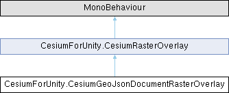
A raster overlay that rasterizes a GeoJSON document and drapes it over the tileset. More...
Protected Member Functions | |
| override partial void | AddToTileset (Cesium3DTileset tileset) |
| override partial void | RemoveFromTileset (Cesium3DTileset tileset) |
 Protected Member Functions inherited from CesiumForUnity.CesiumRasterOverlay Protected Member Functions inherited from CesiumForUnity.CesiumRasterOverlay | |
| void | AddToTileset (Cesium3DTileset tileset) |
| When implemented in a derived class, adds the raster overlay to the given tileset. | |
| void | RemoveFromTileset (Cesium3DTileset tileset) |
| When implemented in a derived class, removes the raster overlay from the given tileset. | |
Properties | |
| CesiumGeoJsonDocumentRasterOverlaySource | source [get, set] |
| The source from which to load the GeoJSON document. | |
| string | url [get, set] |
| The URL from which to load the GeoJSON document. | |
| long | ionAssetID [get, set] |
| The ID of the Cesium ion asset to use. | |
| string | ionAccessToken [get, set] |
| The access token to use to access the Cesium ion resource. | |
| CesiumIonServer | ionServer [get, set] |
| The Cesium ion server from which this raster overlay is loaded. | |
| int | mipLevels [get, set] |
| The number of mip levels to generate for each tile of this raster overlay. | |
| CesiumVectorStyle | defaultStyle [get, set] |
| The default style to use for this raster overlay. | |
| CesiumGeoJsonDocument | document [get, set] |
| Gets or sets the GeoJSON document used by this overlay. | |
| Properties inherited from CesiumForUnity.CesiumRasterOverlay | |
| string | materialKey [get, set] |
| The key to use to match this overlay to the corresponding parameters in the tileset's material. | |
| bool | showCreditsOnScreen [get, set] |
| Whether or not to force this raster overlay's credits to be shown on the main screen. | |
| float | maximumScreenSpaceError [get, set] |
| The maximum number of pixels of error when rendering this overlay. | |
| int | maximumTextureSize [get, set] |
| The maximum texel size of raster overlay textures, in either direction. | |
| int | maximumSimultaneousTileLoads [get, set] |
| The maximum number of overlay tiles that may simultaneously be in the process of loading. | |
| long | subTileCacheBytes [get, set] |
| The maximum number of bytes to use to cache sub-tiles in memory. | |
Additional Inherited Members | |
| Public Member Functions inherited from CesiumForUnity.CesiumRasterOverlay | |
| delegate void | RasterOverlayLoadFailureDelegate (CesiumRasterOverlayLoadFailureDetails details) |
| Encapsulates a method that receives details of a raster overlay load failure. | |
| void | AddToTileset () |
| Adds this raster overlay to the Cesium3DTileset on the same game object. | |
| void | RemoveFromTileset () |
| Removes this raster overlay from the Cesium3DTileset on the same game object. | |
| void | Refresh () |
| Refreshes this overlay by calling RemoveFromTileset followed by AddToTileset. | |
| Events inherited from CesiumForUnity.CesiumRasterOverlay | |
| static RasterOverlayLoadFailureDelegate | OnCesiumRasterOverlayLoadFailure |
| An event that is raised when the raster overlay encounters an error that prevents it from loading. | |
A raster overlay that rasterizes a GeoJSON document and drapes it over the tileset.
This allows stylized vector data to be displayed on terrain and other 3D Tiles.
Definition at line 41 of file CesiumGeoJsonDocumentRasterOverlay.cs.
|
protected |
|
protected |
|
getset |
The default style to use for this raster overlay.
If no style is set on a GeoJSON object or any of its parents, this style will be used instead.
Definition at line 180 of file CesiumGeoJsonDocumentRasterOverlay.cs.
|
getset |
Gets or sets the GeoJSON document used by this overlay.
Setting this property automatically changes source to CesiumGeoJsonDocumentRasterOverlaySource.FromDocument. You can style individual features in the document before setting it by using CesiumGeoJsonObject.SetStyle.
Definition at line 201 of file CesiumGeoJsonDocumentRasterOverlay.cs.
|
getset |
The access token to use to access the Cesium ion resource.
Only used when source is set to CesiumGeoJsonDocumentRasterOverlaySource.FromCesiumIon. If empty, the default token from the ion server will be used.
Definition at line 111 of file CesiumGeoJsonDocumentRasterOverlay.cs.
|
getset |
The ID of the Cesium ion asset to use.
Only used when source is set to CesiumGeoJsonDocumentRasterOverlaySource.FromCesiumIon.
Definition at line 90 of file CesiumGeoJsonDocumentRasterOverlay.cs.
|
getset |
The Cesium ion server from which this raster overlay is loaded.
Only used when source is set to CesiumGeoJsonDocumentRasterOverlaySource.FromCesiumIon.
Definition at line 131 of file CesiumGeoJsonDocumentRasterOverlay.cs.
|
getset |
The number of mip levels to generate for each tile of this raster overlay.
Additional mip levels can improve the visual quality of tiles farther from the camera at the cost of additional rasterization time to create each mip level.
Definition at line 160 of file CesiumGeoJsonDocumentRasterOverlay.cs.
|
getset |
The source from which to load the GeoJSON document.
Definition at line 50 of file CesiumGeoJsonDocumentRasterOverlay.cs.
|
getset |
The URL from which to load the GeoJSON document.
Only used when source is set to CesiumGeoJsonDocumentRasterOverlaySource.FromUrl.
Definition at line 70 of file CesiumGeoJsonDocumentRasterOverlay.cs.