
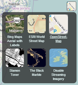
BaseLayerPicker with its drop-panel open.
The BaseLayerPicker is a single button widget that displays a panel of available imagery and terrain providers. When imagery is selected, the corresponding imagery layer is created and inserted as the base layer of the imagery collection; removing the existing base. When terrain is selected, it replaces the current terrain provider. Each item in the available providers list contains a name, a representative icon, and a tooltip to display more information when hovered. The list is initially empty, and must be configured before use, as illustrated in the below example.
| Name | Type | Description | ||||||||||||||||||||||||
|---|---|---|---|---|---|---|---|---|---|---|---|---|---|---|---|---|---|---|---|---|---|---|---|---|---|---|
container |
Element | String | The parent HTML container node or ID for this widget. | ||||||||||||||||||||||||
options |
Object |
Object with the following properties:
|
Throws:
-
DeveloperError : Element with id "container" does not exist in the document.
Example:
// In HTML head, include a link to the BaseLayerPicker.css stylesheet,
// and in the body, include: <div id="baseLayerPickerContainer"
//   style="position:absolute;top:24px;right:24px;width:38px;height:38px;"></div>

//Create the list of available providers we would like the user to select from.
//This example uses 3, OpenStreetMap, The Black Marble, and a single, non-streaming world image.
var imageryViewModels = [];
imageryViewModels.push(new Cesium.ProviderViewModel({
     name : 'Open\u00adStreet\u00adMap',
     iconUrl : Cesium.buildModuleUrl('Widgets/Images/ImageryProviders/openStreetMap.png'),
     tooltip : 'OpenStreetMap (OSM) is a collaborative project to create a free editable \
map of the world.\nhttp://www.openstreetmap.org',
     creationFunction : function() {
         return Cesium.createOpenStreetMapImageryProvider({
             url : 'https://a.tile.openstreetmap.org/'
         });
     }
 }));

 imageryViewModels.push(new Cesium.ProviderViewModel({
     name : 'Black Marble',
     iconUrl : Cesium.buildModuleUrl('Widgets/Images/ImageryProviders/blackMarble.png'),
     tooltip : 'The lights of cities and villages trace the outlines of civilization \
in this global view of the Earth at night as seen by NASA/NOAA\'s Suomi NPP satellite.',
     creationFunction : function() {
         return Cesium.createTileMapServiceImageryProvider({
             url : 'https://cesiumjs.org/blackmarble',
             credit : 'Black Marble imagery courtesy NASA Earth Observatory',
             flipXY : true
         });
     }
 }));

 imageryViewModels.push(new Cesium.ProviderViewModel({
     name : 'Natural Earth\u00a0II',
     iconUrl : Cesium.buildModuleUrl('Widgets/Images/ImageryProviders/naturalEarthII.png'),
     tooltip : 'Natural Earth II, darkened for contrast.\nhttp://www.naturalearthdata.com/',
     creationFunction : function() {
         return Cesium.createTileMapServiceImageryProvider({
             url : Cesium.buildModuleUrl('Assets/Textures/NaturalEarthII')
         });
     }
 }));

//Create a CesiumWidget without imagery, if you haven't already done so.
var cesiumWidget = new Cesium.CesiumWidget('cesiumContainer', { imageryProvider: false });

//Finally, create the baseLayerPicker widget using our view models.
var layers = cesiumWidget.imageryLayers;
var baseLayerPicker = new Cesium.BaseLayerPicker('baseLayerPickerContainer', {
    globe : cesiumWidget.scene.globe,
    imageryProviderViewModels : imageryViewModels
});